Fine-spatial Paleoecological Investigations Towards Reconstructing Late
Holocene Environmental Change, Landscape Evolution, and Farming
Activity in Barrees, Beara Peninsula, Southwestern Ireland
Anette Overland1,* and Michael O’Connell1
Abstract - Long-term environmental change and human impact have been reconstructed at fi ne spatial and temporal resolutions
in an archaeologically rich, and fl oristically interesting, part of southwestern Ireland, namely the Beara peninsula,
County Cork. Detailed pollen and macrofossil analyses, and radiocarbon dating have been carried out on several short peat
monoliths, and on a peat core and a lake core from small basins. Landscape evolution, vegetation dynamics, and farming
activity from the end of the Neolithic (c. 2500 B.C.) to the present day, i.e., the period of greatest human impact in
southwestern Ireland, have been reconstructed. While signifi cant opening-up of the landscape began relatively early in the
Bronze Age (between c. 2400–2100 B.C.), the main woodland clearances took place in the later Bronze Age (beginning
c. 1400 B.C. and continuing into the Iron Age, i.e., to c. 400 B.C.). In the mid- and later Iron Age, there was considerable
fi ne-scale spatial variation, with activity being concentrated mainly in the uplands (at c. 200 m asl) and at lower elevations.
Radiocarbon dating and pollen evidence show that the linear stone-wall system, now partly obscured by shallow peat, was
laid out towards the end of the Iron Age (c. A.D. 400) in the context of a largely open landscape. While the initial foci of
bog growth appear to relate to the late Neolithic/beginning of the Bronze Age, widespread development of blanket bog was
essentially a phenomenon of the late 1st/early 2nd millennium A.D. It was probably favoured by wetter and cooler conditions
during the Little Ice Age. Detailed records are presented for the fi lmy ferns, Hymenophyllum tunbrigense, H. wilsonii, and
Trichomanes speciosum, and also Myrica and Ulex, both shrubs with pronounced, oceanic distribution patterns.
1Palaeoenvironmental Research Unit, Department of Botany, National University of Ireland - Galway, Galway, Ireland.
*Corresponding author - anette.overland@nuigalway.ie.
Introduction
The potential of pollen analysis as a tool for
paleoenvironmental reconstruction has long been
recognised. Initially used as a tool for reconstructing
woodland dynamics during the post-glacial
(e.g., Erdtman 1924; L. von Post in 1916, reported
by Fries 1967; Jessen 1949), the technique has, in
the meantime, been refi ned in most respects including
methods of sample preparation, range of
palynomorphs identifi ed, improved certainty in the
identifi cation of critical palynomorphs, and data
interpretation, so that not only woodland history but
also farming activity and the role of factors such as
climate change can be reconstructed with a degree
of completeness and certainty never envisaged by
the original practitioners. The main strength of the
technique is the ability to generate a continuous or
near-continuous record provided that continuous,
or at least close-interval, sampling is carried out.
It can also provide evidence of fi ne-scale spatial
variation in the natural/semi-natural vegetation (this
may include not only woodland, but also bog and
heath communities), and farming impact. A prerequisite
for such fi ne-scale studies is the availability
of suitable basins of deposition with deposits that
enable local as distinct from regional records to be
obtained. Such deposits may take a variety of forms
including peats that have accumulated in small hollows
including kettle holes, mor humus deposits that
have accumulated within woodland contexts, soils
with good pollen preservation, such as where sealed
as a result of spread of bog, and small bogs and lakes
(e.g., Behre and Kučan 1995, Odgaard 1994, Waller
and Schofi eld 2007). The reconstructions reported
here derive from several deposit types and are complemented
by results from parallel archaeological
excavation and survey.
Theoretical studies show that to obtain very localised
records, basins with small diameter (100 m
and preferably less) are required (Sugita 1994, 2007).
Empirical data, especially those derived from situations
where human impact is known or at least can be
accurately estimated from archaeological/historical
evidence (cf. Berglund 1998, Molloy and O’Connell
1995), further indicate not only the critical importance
of small basin size but also other factors such as fi ltering
effects of carr vegetation that often fringes bogs
and lakes and potential over-representation of pollen
derived from plants growing at the sampling site (cf.
Bunting 2003, Tauber 1965). The latter can be particularly
critical in the case of mires that give rise to
pollen that are largely indistinguishable from pollen
that derive from plants growing on mineral soils, e.g.,
Poaceae, Cyperaceae, and Ericoids (see below). Local
conditions, including topography and climate—especially
wind speeds and prevailing wind direction—
also have an important bearing on pollen dispersal and
hence pollen records. In the investigations presented
here, particular attention is paid to the local contexts
of the sampling locations, and the most important caveats
regarding the interpretations are indicated and
taken cognizance of in the reconstructions.
2008 Journal of the North Atlantic 1:37–73
38 Journal of the North Atlantic Volume 1
Figure 1. Maps at various scales showing location and main features of the study area. (a) Map of southern Ireland—the
Beara peninsula is shaded and centers of population (B = Bantry, C = Cork, K = Killarney, L = Limerick) are indicated; (b)
Detail of southwestern Ireland centered on the Beara peninsula—towns (Ba = Bantry, CB = Castletown Bere, Ke = Kenmare),
villages (Ar = Ardgroom, Ey = Eyeries, Gl = Glengarriff), pollen sites (Ca = Cashelkeelty, Ur = Uragh Wood) and
relief are shown; (c) The study area and immediate surrounds—roads, contours, the main archaeological fi eld monuments
and village of Eyeries are shown. An arrow points to Loch Beag; and (d) Detailed map of the study area showing pollen
sampling sites and archaeological features including stone fi eld walls as recorded during archaeological survey.
2008 A. Overland and M. O’Connell 39
The present investigations were undertaken,
in the fi rst instance, to provide an environmental
context for archaeological survey and excavation
in the under-explored and mainly upland landscape
that lies between Ardgroom and Castletownbare on
the Beara peninsula, hereafter referred to as Beara
(Fig. 1). As in southwestern Ireland generally, it is
usually assumed that prehistoric activity was concentrated
in the Bronze Age rather than the Neolithic or
Iron Age, not only because of the high frequency of
monuments and features datable to the Bronze Age
(e.g., wedge tombs, stone circles, standing stones,
and fulachta fi adh, i.e., burnt mounds; O’Brien
2000, in press; Power 1992), but also due to the
paleoecological evidence from Cashelkeelty and the
wider Cork/Kerry region (see below).
The paleoecological investigations are spatially
circumscribed in that they relate specifi cally to the
partially peat-covered landscape of Barrees, a townland
between Ardgroom and Eyeries (Fig. 1). The
northeast/southwest grain of the landscape originated
in the Hercynian (Armorican) uplift of late
Paleozoic age that resulted in tight folding and
exposure of erosion-resistant Old Red Sandstone of
the Upper Devonian that forms the mountain ranges
in this part of Ireland. The Hercynian folding also
resulted in metalliferous deposits of copper, manganese,
and barites in southwest Cork that formed the
basis of Bronze Age and subsequent copper mining
(Callaghan and Forsythe 2000; O’Brien 1996, 2004;
Pracht 1997). Late Devonian and Carboniferous
sandstone, limestone, and shale survive mainly in
restricted coastal areas (MacCarthy 2007a, b; Pracht
1997) where relatively fertile, brown podzols occur.
These contrast with the skeletal soils and peaty
podzols derived from the nutrient-poor sandstones
and overlying drift. These areas support mainly
rough pastures, heaths, and peatlands (Conry and
Ryan 1963), which characterize the landscape under
investigation here. Though lying well within the
eastern limits of the Killarney-Killumney ice-sheet
(last glaciation), glacial deposits are generally thin
and patchy, and derive largely from local bedrock,
which has a major infl uence on soil types.
As regards previous paleoenvironmental investigations
from the region, those by Lynch (1981) at
Cashelkeely (Fig. 1b), 9 km to the north of Barrees,
are the most detailed and relevant. The pollen profi le,
Cashelkeelty I, from a small peat basin near the main
stone circle (Bronze Age), spans the interval 7000
B.C. to recent times (dates quoted as B.C. or A.D.
are calibrated/calendar years). Human impact begins
in the Bronze Age (shortly before 2000 B.C.) and is
maintained until the late Iron Age, when what has
come to be regarded as the Late Iron Age Lull, i.e.,
a period of reduced activity in the early centuries of
the fi rst millennium A.D. (cf. Molloy and O’Connell
2004), is recorded. In the historical period, there is
evidence for sustained activity that was maintained
until recent times. Local initiation of peat growth at
c. A.D. 900 provides a terminus ante quem for a prebog
stone wall at the site.
A profi le from a small hollow (8 x 15 m) in Uragh
Wood, near L. Inchiquin, some 9 km northeast of
Barrees, records local woodland dynamics starting
at c. 1400 B.C. (Fig. 1b; Little et al. 1996). The fi rst
and short-lived disturbance was recorded at about the
B.C./A.D. transition. Shortly after this (c. A.D. 300),
pine became locally extinct. A major disturbance
phase involving clearance of oak occurred at about
A.D. 1700. Little et al. (1996) suggest that soil podzolization
took place some centuries prior to this.
A synthesis of research in the Killarney area
and new pollen diagrams are provided by Mitchell
and Cooney (2004), while Mighall and co-workers
have carried out paleoecological investigations on
the Mizen peninsula (Mighall and Lageard 1999;
Mighall et al. 2000, 2007), the main region for
Bronze Age mining in Ireland (O’Brien 2003).
A valuable critique of the evidence from archaeological
and historical sources relating to the
period from the arrival of the Normans in Ireland
(A.D. 1169) to the end of the Gaelic lordship by the
O’Sullivan Beare (the Gaelic chieftain clan of Beara)
in the early 17th century has recently been published
(Breen 2005). Much of the fi eld evidence and the historical
sources relate, however, to the coastal parts
and so, while providing useful background information,
are of limited direct relevance (cf. also Dickson
2005). The identifi cation of a large number of upland
hut sites (age uncertain, probably medieval) on Beara
is interesting in that it shows that today’s marginal
landscapes were extensively used in the past (Breen
2005:51). In the context of the present study, the idea
that medieval landscapes under Gaelic control were
not enclosed is also noteworthy (Duffy 2007), and
Breen (2005:110–112) argues that this was also true
for Beara. In addition to the above archaeological/
historical research, accounts of life and landscape
left by travellers to this once remote part of Ireland
provide additional insights, but environmental information
is limited (Durell and Kelly 2000).
The present paper, with its focus on the later
Holocene, i.e., Bronze Age to modern times, provides
insights into the development of what might
be regarded as a marginal or liminal landscape in
the regional contexts of Beara, and indeed western
Ireland generally. The focus is on local woodland
dynamics, land-use, and the development of the
present-day, peat-covered landscape that largely
obscures a network of stone walls that pre-date the
earliest Ordnance Survey (OS) maps of the early
1840s. It constitutes the fi rst such detailed, fi ne-scale
paleoecological study for southwestern Ireland.
40 Journal of the North Atlantic Volume 1
Description of the Study Area
The study area lies in a relatively sheltered,
northwest-facing valley (elevation c. 100–250 m
asl), on the lower western slopes of the Miskish
Mountains (locally these reach 318 m asl; maximum
621 m asl) and 2 km from Coulagh Bay to the west
(Fig. 1c–d). Present-day farming is concentrated
in the lowlands. The fi rst detailed Ordnance Survey
map (OS 6-inch 1:10,560 scale map; surveyed
1842) shows a fi eld pattern very similar to that of
today, i.e., more or less confi ned to the valley fl oor,
to the east of Loch Beag. Part of the present-day
valley fl oor supports semi-open patches of Atlantic
oak woodlands (Blechno-Quercetum petraeae scapanietosum;
Fig. 2), i.e. the typical fern and bryophyterich
sessile oak woodlands on acidic soils of western
Ireland and Britain (Cross 2006, Kelly 1981). This
woodland is not shown on the various editions of the
6-inch OS maps, and there are no old trees present
today. Woodland appears not to have been a feature
of the landscape at the time of the early surveys, i.e.,
the 1840s and later. Quercus petraea is the main
tall-canopy tree today and Betula pubescens and Ilex
aquifolium are common (plant nomenclature follows
Stace [1997] for vascular plants, Smith [1978] for
mosses and Watson [1981] for liverworts). Other
common and typical plants include the fi lmy fern
Hymenophyllum tunbrigense and liverworts such as
Scapania spp. and Saccogyna viticulosa (cf. Plate
II in Cross 2006). This open woodland lies mostly
at or below 100 m asl, but patchy outliers extend to
c. 150 m elevation (Fig. 2).
Ulex europaeus forms a band of open shrubby
vegetation c. 10–20 m wide where the open woodland
ceases. Above this, there are rough pastures,
wet heath, and blanket bog (Fig. 2). Rushes (Juncus
effusus, J. acutifl orus, J. articulatus, and J. squarrosus)
dominate the rough pastures. Molinia caerulea
tussocks are prominent on shallow peat, whereas
Sphagnum spp., Molinia, Nardus stricta, and Potentilla
erecta are common on deeper peat. Other common
acidophilous species include Anagallis tenella,
Carex fl acca, C. binervis, Drosera rotundifolia,
Erica tetralix, Galium saxatile, and Pedicularis
sylvatica. Species with restricted distribution in Ireland
include Anthemis nobilis, Euphorbia hyberna,
Pinguicula grandifl ora (also P. lusitanica and P. vulgaris),
and Ulex gallii. The ferns Hymenophyllum
wilsonii and Blechnum spicant occur in the more upland
parts of the study area within heathy vegetation
where local topography and aspect combine to give
some shade and shelter from the prevailing southwesterlies
and direct radiation. Associated species
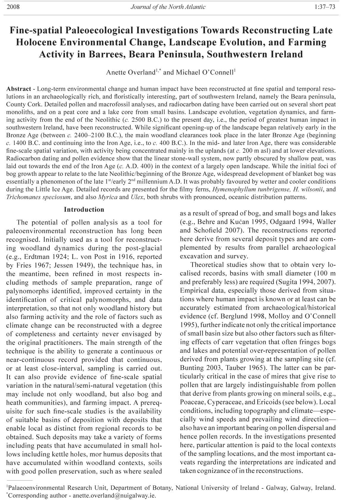
Figure 2. View towards the main area of archaeological survey and excavation from a low hill at the northeast side of Loch
Beag (the lake is partly visible in foreground). Heath dominates in the foreground, followed by pastures and Q. petraea
woodland, and beyond these heath, rough pasture and blanket bog, where the short monoliths and the long core, BAR-L1,
were taken. The area of main archaeological interest is enclosed by an ellipse (photograph: October 15, 2004).
2008 A. Overland and M. O’Connell 41
include the leafy liverwort Scapania gracilis and
mosses such as Hypnum jutlandicum, Hylocomium
splendens, Pseudoscleropodium purum, Sphagnum
palustre, S. capillifolium, and S. subnitens.
The pronounced oceanic climate is an important
factor infl uencing species distribution at both
regional and local levels, and has undoubtedly also
infl uenced general landscape character, especially
as regards blanket bog and heath development. The
climate is characterised by mild winters with little
frost or snow. January air temperature is 7 °C (mean
daily) and 4.5 °C (mean daily minimum), while the
July mean reaches only 15.5 °C and mean daily
maximum is 18 °C. Rainfall is high (c. 1600 mm
per annum) and frequent (c. 200 wet days, i.e., days
with ≥1 mm precipitation). Winds are predominantly
from the southwest and so are generally warm and
rain-bearing. Average wind speed is relatively high
(6 m sec-1) (temperatures and precipitation refer
to the periods 1931–1960 and 1941–1960, respectively;
temperatures quoted are reduced to mean sea
level; Rohan 1975).
The study area harbours a variety of archaeological
features including a Bronze Age copper
mine, fulachta fi adh (burnt mounds), hut sites and
enclosures of various sizes, as well as a network
of ancient stone walls, many of which are partially
obscured by shallow peat (Fig. 1; details in O’Brien,
in press). A particular focus of the present investigations
was to establish a chronology for these walls,
the environmental context in which they were built,
and especially the land-use patterns associated with
their construction and use.
Methods
The paleoecological research was greatly
facilitated by the possibility of collecting a series
of short monoliths from trenches freshly cut in
the course of archaeological excavations. As peat
thickness in the vicinity of the walls is generally
not much more than 50 cm (and often less), the
records obtained from these sources are relatively
short and generally extend back to no more than
about two millennia.
The short records from monoliths BAR1 to
BAR5 are complemented by two longer records
from a peat core and a lake core, respectively. The
former, referred to as BAR-L1, was taken from
relatively deep peat that accumulated in a small
basin (c. 40 m diameter) within the area of prime
archaeological interest (further details regarding
cores and monoliths and sampling in the fi eld are
given in Table 1; photographs and additional details
are in Overland and O’Connell, in press). Lying at c.
140 m asl, it is the lowest sampling site apart from
Loch Beag, and is about 350 m distant from the
woodland remnants near the bottom of the valley.
The uppermost meter of peat had been cut from half
of the basin. In the cutover part, a substantial oak
trunk was exposed by peat cutters, and a timber layer
was encountered in the non-cutover part at c. 90 cm
from the intact surface during trial coring. Sampling
was carried out on the intact bog surface at a point
where the peat was thickest as determined by a
gouge corer.
The lake record is based mainly on core BEG1
taken from Loch Beag (literally Small Lake; lake
unnamed in the OS maps). This lake lies in a small
closed basin that is sheltered from the prevailing
southwesterlies by high ground but open to the
valley and the area of main archaeological interest
to the northeast (Figs. 1, 2; further details in
Overland 2007). The results from Loch Beag, while
briefly considered here, will be described more
fully elsewhere.
In the case of the short monoliths (BAR1–
BAR5), depths were noted with respect to the
mineral ground, i.e., positive depths indicate depths
below mineral ground, while negative depths indicate
height above the mineral ground/peat interface.
In BAR-L1, depths were noted with respect to the
present-day bog surface. In the case of the Loch
Beag cores, depths are with respect to the surface
of the coring platform that was supported by, and
fl ush with, the semi-fl oating scraw (corresponds
approximately to the lake-water surface).
Close-interval sub-sampling was carried out
as follows. Samples of 1 cm3 and 1 cm thick were
taken at equal intervals where this was practical
(BAR-L1; BEG1), or at irregular intervals as to
avoid sampling over layer boundaries (BAR1 and
BAR3). Samples were prepared for pollen analysis
using standard procedures including HF treatment
to remove mineral matter (Fægri and Iversen 1989).
A known number of Lycopodium spores was added
to each sample at the beginning of the preparation
procedure to facilitate estimation of pollen
concentration. Samples were mounted in glycerol,
and counted under phase contrast using a Leica
DM LB2 microscope fi tted with a phase contrast
Planapo 63/1.4 objective that gave a magnifi cation
of 788. In general, at least 1000 pollen (excluding
bog taxa) were counted per sample. Pollen and spore
identifi cation followed mainly Fægri and Iversen
(1989). Other authorities consulted include Moore
et al. (1991), Beug (2004), and Reille (1992, 1995).
Cereal-type pollen were distinguished following
the criteria in Beug (2004; see Behre [2007] for
overview on evaluation of cereal pollen). During
counting, large Poaceae pollen with a large pore and
annulus, i.e., fulfi lling the criteria given by Beug
for cereal-type pollen, were categorised according
to size as follows (length of longest axis of grain
42 Journal of the North Atlantic Volume 1
cited): 40–44 μm, 45–49 μm, and ≥50 μm. In
addition, Secale pollen were distinguished. Spores
of the fi lmy ferns were distinguished as follows:
large size (62–74 μm) and distinctive polymorphic
echinae enable Hymenophyllum wilsonii to be
separated with confi dence from the much smaller
spores of H. tunbrigense (40–48 μm; measurements
according to Page [1997], which, presumably, relate
to untreated spores) and T. speciosum. Features such
as the shape of the spore, and the distribution and
shape of the sculptural elements enable Trichomanes
to be distinguished from H. tunbrigense. The former
is rounder and hence more regular in outline
with trilete markings that extend almost to the
circumference. The surface texture consists mainly
of low, verrucae-like projections and well-spaced,
long (c. 2 μm), narrow, pointed projections that are
often inclined by several degrees and also curved. In
outline, H. tunbrigense tends to be more triangular
than round and has a long, pronounced trilete
marking. The sculpture consists of many echinaelike
projections (c. 2 μm long), close to being
isosceles triangular in shape (i.e., broad base) and
lacking the heterogeneity of shape and size seen in
H. wilsonii; in surface view, the base of many of the
projections appear elongated.
Table 1. Details of sampling at Barrees and summary of the main analyses carried out.
Core/monolith Latitude and
and analyses* longitude Additional details relating to sample location and sampling
Short monoliths
BAR1 51°42'25.2"N, From T1 at NW side of the main wall enclosure. Monolith included mineral soil and
Alt: 182 m 9°55'03.2"W overlying peat taken c. 60 cm from edge of stone wall (uphill side). All of overlying
Pollen (20) peat sampled. An additional small monolith, BAR1(2)—a 6-cm thick slice of brown
14C (10)α organic-rich sandy/silty soil—was taken from beneath a large stone that formed part
of the foundation of the wall
BAR2 51°42'19.7"N, Uphill of BAR1 and near round enclosure, A. Basal peat (c. 20 cm) from beside the
Alt: 220 m 9°55'02.8"W wall sampled.
Pollen (2)
14C (2)
BAR3 51°42'17.0"N, Monolith consisting of mineral soil and basal peat removed from uphill side of a
Alt: 218 m 9°54'53.0"W substantial stone wall. Uppermost c. 50 cm of peat not sampled.
Pollen (12)
14C (3)
BAR4 51°42'29.3"N, Short monolith consisting of peat taken from beside a stone wall situated above the
Alt: 150 m 9°55'12.4"W small basin (53 m to the SE) where BAR-L1 was taken. Note: an additional 14C date
Pollen (1) was obtained subsequently by W. O’Brien.
14C (1)
BAR5 51°42'27.2"N, T5, at approximately the same altitude as T4, was cut through a low wall. BAR5-1,
Alt: 155 m 9°55'18.7"W consisting of peat, was taken from beside the wall (downslope side). BAR5-2
Pollen (2) consisted of mineral soil beneath a large stone of the wall.
14C (3)
Bog core
BAR-L1 51°42'30.4"N, Core from a small hollow 65 m to the N.E. of BAR4 and below large enclosure
Alt: 140 m 9°55'10.6"W (BAR1). Uppermost 40 cm removed as a monolith. Remaining peat sampled in a
Pollen (51) 10 cm diameter plastic pipe; basal mineral soil recovered. Monolith+core (referred
14C (9) to as core BAR-L1) was 266 cm long.
Lake core
BEG1 51°42'4.3"N, Parallel, overlapping cores, BEG1 and BEG2, were taken beneath a scraw that has
Alt: 103 m 9°55'32.5"W recently developed as a result of rapid lake-infi lling. Open water occupies an area of
Pollen (175) c. 50 x 30 m; Loch Beag was probably double this size for much of the Holocene.
14C (17)
*Alt = altitude; numbers of pollen and 14C samples are given in parentheses; T = Trench α BAR1; 14C samples as follows:
5 samples for AMS dating (mainly Juncus seed and some fi ne charcoal fragments. The sample, BAR1-3, was too small
to be dated; another sample (BAR1-7) was submitted for conventional dating.
3 samples consisting of 1-cm thick peat slices for conventional dating.
1 sample from a pre-wall context for AMS dating, i.e., Juncus seed extracted from the mineral soil preserved beneath
the stone wall.
1 sample consisting of Salix charcoal from a mineral soil context beneath a stone presumed to have been displaced in
antiquity from the wall.
2008 A. Overland and M. O’Connell 43
Selected non-pollen palynomorphs (NPP)
including fungal spores, Erica tetralix seed
epidermis fragments, and microscopic charcoal
(>30 μm; here referred to as micro-charcoal) were
also counted.
The pollen data are expressed as percentages
based on a total terrestrial pollen sum (TTP) and
also as concentrations (grains cm-3). Taxa excluded
from the pollen sum include bog taxa, corroded and
unknown grains (generally few), charcoal, and NPP
including fungal spores. The percentage representation
of these taxa was calculated relative to TTP and
the sum of taxa pertaining to the component in question.
Pollen assemblage zone (PAZ) boundaries were
drawn where major changes occur in the percentage
curves as determined by visual inspection.
The matter retained in the 100-μm sieves after
KOH treatment of the pollen samples was checked
for macrofossils, and semi-quantitative estimates—
rare (+), occasional (1), frequent (2), and abundant
(3)—of macrofossils, macro-charcoal, and mineral
matter were made. In addition, macrofossil analysis
was carried out on samples with a volume of
c. 35 cm3 to get material suitable for AMS 14C dating.
The material retained in a 125-μm mesh sieve was
scanned for macrofossils and other entities using a
Leica MZ125 stereomicroscope. Bulk peat samples
were also submitted for conventional 14C dating
(BAR1 and BAR3). Ash content, i.e., the amount of
mineral matter present, was determined by burning
dried samples to constant weight for six hours in Ni
crucibles at 550 °C.
Results and Interpretation—Short Monoliths
Pollen diagrams relating to the short monoliths
are presented in Figures 3–7. Conventions followed
in these and the other pollen diagrams include
(a) curves/histograms with a magnifi ed x-axis are
not in-fi lled, (b) a closed circle is used to emphasize
presence where values are small and hence may go
unnoticed, and (c) a “+” indicates a record made
by scanning after pollen counting was completed.
Macro-fossil and other data are also presented
within the pollen diagrams.
In the short monoliths, where the focus was on
mineral soils and the overlying peat, interpretation
of the pollen data is not straightforward because of
the complexities of the processes involved in the
incorporation and preservation of pollen in mineral
soils (cf. Dimbleby 1985, Havinga 1971, O’Connell
1986). Complications may arise from the presence
of residual older pollen in soils, the probability of
vertical movement of pollen within the profi le, and
differential preservation of corrosion-resistant pollen
and spores (especially fern spores). The local
soils are acidic and podzolised (iron pan noted only
in BAR3) and so poor preservation is not regarded
as seriously distorting the results.
As regards pollen source area, soil samples
refl ect largely the local vegetation at and near the
sampling site. As peat begins to accumulate and
expand laterally, the non-bog pollen increasingly
refl ect regional vegetation change.
In presenting pollen data from peat profi les, it
is usual practice to exclude bog taxa so as to avoid
distortion of curves due to over-representation of locally
produced pollen. On the other hand, bog taxa
are best included in the pollen sum in the case of
spectra relating to the mineral soils (since what is
refl ected is mainly the local environment which is
normally also of greatest interest). The use of different
pollen sums in the same pollen diagram is not,
however, practical, and so a pollen sum based on
TTP that excludes bog taxa has been used. It should
be borne in mind that bog taxa are also infl uenced by
grazing (Bleasdale and Sheehy Skeffi ngton 1992).
This fact is particularly relevant in this instance as
the largely peat-covered uplands were probably always
used for grazing, even if to varying degrees.
The 14C dates for the short monoliths and the
peat core are presented in Supplementary Tables
S1 and S2 (available online at http://dx.doi.org/
10.1656/J080427.s1 and http://dx.doi.org/10.1656/
J080427.s2, respectively; additional details in Overland
and O’Connell, in press). The dates have been
calibrated using Calib ver. 5.0.1 and the IntCal04
calibration curve (Reimer et al. 2004).
Estimating age in the case of short peat monoliths
presents a particular challenge. In addition to
14C dates that give unlikely ages or have a large error
value (see below), age construction is complicated by
the unpredictability of peat accumulation, particularly
at the initial stages of peat growth. In general, peat
accumulation is expected to be initially relatively
slow and then increase when conditions become more
favorable for bog plants, as organic matter and soil
wetness increase and decomposition rates decline
with increased wetness. The results from the various
profi les are now considered and local environmental
change reconstructed for each site.
BAR1 (Trench 1)
At the point along the trench across the wall of
the large enclosure where the monolith BAR1 was
taken, there was a localised depression of c. 12 cm
in the mineral soil surface (Fig. 3). This depression
may be the imprint of a stone that was used in wall
construction. It was fi lled with grey-brown silt that
had a considerable organic component (see below).
Stratigraphy. The main stratigraphic features are
as follows (Fig. 4). The basal mineral soil, on which
the wall was built, was low in organics (layer 1).
Layer 2 (0 to -21 cm) consisted of sandy silt with con44
Journal of the North Atlantic Volume 1
Figure 3. Profi le BAR1: percentage pollen diagram (AP and NAP). Abbreviations: Tr = Trifolium repens, Br = Brassicaceae spp. (values <1% and mainly <0.2%).
2008 A. Overland and M. O’Connell 45
Figure 4. Profi le BAR1: composite percentage and bog taxa pollen curves, micro- and macro-charcoal, selected pollen concentration curves, ash values, macrofossils, and photograph
of part of Trench 1. The ranging rod marks the position where the monolith was taken. Position of samples taken for 14C dating is indicated. Macro-charcoal is indicated by histograms
and “+” using the same abundance scale as that used for the macrofossils. The Juncus records consist of seed.
46 Journal of the North Atlantic Volume 1
Figure 5. Percentage pollen spectra from BAR2, BAR4, and BAR5.
2008 A. Overland and M. O’Connell 47
Figure 6. Profi le BAR3: percentage pollen diagram (excluding bog taxa) and concentration curves for selected composite taxa.
48 Journal of the North Atlantic Volume 1
Figure 7. A. Profi le BAR3: composite and bog taxa percentage pollen curves, micro- and macro-charcoal records, macrofossil records, ash curve, and stratigraphy as recorded in the laboratory.
B. Photograph of Trench 3 immediately prior to removal of monolith and stratigraphy as recorded in the fi eld. Note: the vertical scale is compressed compared with A.
2008 A. Overland and M. O’Connell 49
siderable organic content; sublayer 2b was more organic-
rich and darker. This layer was overlain by peat
as follows: a fi ne, dark, charcoal-rich peat that formed
a distinctive layer (layer 3, -21 to -31 cm); highly decomposed
brown peat with abundant fi ne roots (layer
4, -31 to -50 cm); dark, relatively charcoal-rich peat
with many roots including woody roots (layer 5, -50
to -58 cm); and a highly fi brous peat that formed the
rooting zone of present-day vegetation (layer 6, -58 to
-63 cm).
Chronology. The results of the 14C dating are plotted
in Figure 8. The age/depth curve (Fig. 8) gives
what is regarded as the most probable age/depth relationship
based on the available evidence that includes
not only 14C dates but also lithological and pollen analytical
features. It is assumed that the accumulation
rate is low at the base of the profi le, and that once organic
matter began to build up, the accumulation rate
increased, an assumption supported by the 14C data.
The AMS 14C date based on Juncus seed from
mineral soil beneath the wall (2220 ± 270 B.P.) has
a very large error; the date is regarded as broadly
indicative of an age in the end of the fi rst millennium
B.C. (1σ probability range is 743 B.C.–A.D. 53).
The AMS 14C date, 975 ± 35 B.P., derived from Salix
charcoal beneath a fallen stone, appears acceptable.
It suggests that peat growth had not commenced before
c. A.D. 1100, and wall construction had taken
place before this, and possibly considerably earlier.
The lowermost AMS 14C date from the monolith,
1860 ± 120 B.P., is from mid-layer 2a. This layer is
regarded as infi ll in the depression left after removal
of a stone for wall construction. It follows that the
infi ll accumulated after wall construction and prior
to peat growth. The 1σ probability range for this date
is A.D. 21–325. Wall construction seems to have
taken place sometime during the fi rst three centuries
A.D., after which the process of infi lling the depression
commenced.
The two 14C samples from the lower part of layer
2b indicate very different ages. The AMS 14C date
2280 ± 330 B.P. has a very large error margin and so
Figure 8. Proposed age/depth relationship for BAR1 is shown by the dashed line. The calibrated 1σ age range (width of
rectangle) and the median probability (vertical line) for each 14C date are indicated.
50 Journal of the North Atlantic Volume 1
shortly after wall construction in the early centuries
A.D. (probably towards the end of the fi rst century
A.D. if contemporaneous with the nearby circular
enclosure, i.e., Site A), and layer 2b, which also has
a high mineral content, presumably formed prior to
local peat initiation. The age-depth model suggests
that subzone BAR1-2b spans the interval c. A.D.
850–1150 (Fig. 8).
Pollen assemblage subzone BAR1-2a (-1 to -6.5
cm) is rather similar to BAR1-1, i.e., the pre-wall
mineral soil spectra. Alnus, however, is more strongly
represented, and P. lanceolata and especially Poaceae
have lower values. Occasional cereal-type pollen
were recorded, including a Secale-type pollen at
-3 cm (Fig. 3).
Vegetation and land use were broadly similar
to that which pertained during pre-wall construction.
Grasslands, though, were not as important as
before, there was cereal growing (but minimal), and
relatively species-rich, alder-dominated woodlands
were important. Holly and the fi lmy ferns, H. tunbrigense
and especially H. wilsonii, were common,
and six spores of T. speciosum (Killarney fern) were
recorded (Fig. 3).
The subzone BAR1-2b (-9 to -17 cm) is transitional
between BAR1-2a and BAR1-3 in that the
percentage and concentration values for Alnus and
Poaceae change substantially, the former decreasing
and the latter increasing (Figs. 3 and 4). This
shift in representation suggests replacement of
alder-dominated woody vegetation by grassland.
A high diversity of non-arboreal pollen (NAP)
suggests species-rich grasslands that presumably
served as pasture. Cereal-type pollen achieve their
highest representation in the profile (max. 0.5%
in -11 cm), and there are also records for plants
associated with disturbed ground, trampling, and
arable farming (cf. Galeopsis-type, Brassicaceae,
and Polygonum, which includes occasional grains
of P. aviculare and P. bistorta-type pollen). These
features suggest disturbance, including arable
farming, at or in the general vicinity of the site.
The high Cyperaceae representation suggests
wet, sedge-rich grasslands with Potentilla erecta
(the most likely source of the Potentilla-type pollen)
and possibly Narthecium. Juncus seed (mainly
J. effusus/conglomeratus and also J. bufonius;
Fig. 4) are well represented, which suggests that the
local pastures were rushy and wet.
The decline in AP as the subzone ends is most
likely the result of increased farming pressure that
is also manifested in increased micro-charcoal representation.
An increase in Sphagnum suggests local
initiation of bog. The age-depth model suggests that
peat initiation at the site started in the early 2nd millennium
A.D.
is of little use. As regards the lower sample for which
conventional 14C dates are available, the alkali extract
gave the older date (1150 ± 40 B.P.; 920 ± 60 B.P. for
the humin fraction). The situation is similar in the
case in the sample immediately above. The dates
for the humin fractions are probably too young due
to root penetration. The dates c. A.D. 1000 and A.D.
1150 are suggested as appropriate for the depths in
question (-12.5 and -19 cm, respectively). This estimate
takes into account the AMS 14C date for the Salix
charcoal and likely sedimentation patterns.
The AMS 14C date 905 ± 45 B.P. from the top of
the charcoal-rich layer (layer 3) appears to be too old
if the dating outlined above is correct (2 mm year-1
accumulation rate would be required, which is unrealistic
given the peat composition). It is therefore
dismissed, as is the AMS 14C date 1110 ± 120 B.P.
from layer 4, which is also regarded as too old.
As regards the uppermost conventional 14C date,
the 14C content in the humin component was in
excess of 100%, i.e., post-modern, and hence is discounted.
The alkali extract, on the other hand, gave
what appears to be an acceptable date (360 ± 35 B.P.,
i.e., c. A.D. 1550) on the basis of overall sedimentation
patterns and given that the secondary rise of
Pinus (18th century phenomenon) fi rst registers at
-51 cm (Fig. 3).
Paleoenvironmental reconstruction (Figs. 3 and 4)
Zone BAR1-1; pre-wall pollen spectra (1 and
3 cm; end of 1st millennium B.C.). These spectra
are from the mineral soil that was sealed as a result
of wall construction. They refl ect vegetation and
land use locally in the years (possibly decades)
prior to wall construction. Relatively species-rich
grassland dominated in which grasses, P. lanceolata,
various Asteraceae species, and other herbs played
an important role. Sedges and rushes (Juncus seed
frequent) were also important, but other bog/heath
plants (e.g., Calluna, Erica spp., Sphagnum) were
poorly represented. Alder was common in the vicinity
of the site, and oak, hazel, birch, willow, and
holly were probably also common in the immediate
vicinity (arboreal pollen (AP) is at 41% and 31% in
the lower and upper spectra, respectively).
In general, the pollen and macrofossil evidence
indicates that, at or in the vicinity of the site, the
landscape was relatively open, but trees and especially
alder were common, and there was little or no
bog/heath development.
Zone BAR 1-2; -1 to -17 cm (c. A.D. 1–1150).
This zone is subdivided into subzones BAR1-2a and
BAR1-2b, which, in turn, relate to the lithological
layers with corresponding numbers (see above). It
is assumed that layer 2a—infi ll of a depression left
by a stone used in wall construction—began to form
2008 A. Overland and M. O’Connell 51
Zone BAR1-3; -21 to -28 cm (c. A.D. 1150–
1450). This PAZ relates to layer 3, i.e., the dark, charcoal-
rich layer that formed the basal peaty deposits.
The zone is dominated by Poaceae (achieves 80%),
AP is very low (c. 7%), and there is an increase in
Sphagnum and Potentilla-type (presumably P. erecta,
a species of acid soils and tolerant of burning), but
Ericoids are poorly represented. Both micro- and
macro-charcoal representation is high. These features
suggest a period of intensive land-use with grassdominated
vegetation on shallow peaty soils in which
acidophiles such as Succisa were well represented.
Interestingly, Centaurea nigra (Knapweed) is also
consistently recorded. This plant is a grassland species
that is favored by meadowing and infrequent
burning (Grime et al. 2007). Within the Irish context,
it is recognised as a diagnostic species of meadow
communities (cf. Centaurio-Cynosuretum association;
White and Doyle 1982). The evidence for cereal
cultivation is weaker than in subzone BAR1-2b (occasional
cereal-type pollen and few pollen of weeds
associated with arable activity).
The age-depth model suggests that this phase of
intensive, mainly pastoral-based farming activity
ended shortly before A.D. 1500. The decline may be
connected with increasingly unfavorable conditions
as the climatic downturn associated with the Little
Ice Age became more pronounced. The adverse effects
of the Elizabethan wars of the late 16th century
(also inheritance disputes within the local O’Sullivan
Beare clan) were probably much more serious and are
known to have impinged greatly on farming in southwestern
Ireland (Feehan 2003:84–85).
Zone BAR1-4; -32 to -44 cm (c. A.D. 1450–
1750). Compared with the previous zone, this zone
shows a small increase in Corylus and Salix and a decline
of c. 10% points in Poaceae. The main change,
however, is an increase in bog/heath taxa such as
Calluna, Erica tetralix, and especially Myrica,
which attains 38% (based on TTP+bog taxa). These
changes, and in particular the expansion of Myrica,
may have been facilitated by increased availability of
suitable habitat as a result of bog expansion and a reduction
in farming activity that led to less fi ring of the
vegetation. Ulex (pollen not differentiated to specifi c
level) is recorded throughout and is best represented
in the two lowermost spectra (Fig. 3). The decline
in grazing pressure at the beginning of the zone may
have favoured the spread of furze, i.e., U. europaeus
and U. gallii, both of which are common at local and
regional levels today (see Discussion).
Zones BAR1-5 and 6; -47 to -54 cm (c. A.D.
1750–mid 1900). The secondary rise in Pinus, refl
ecting pine planting in the wider region, is recorded
at -51 cm while other AP curves are at their lowest
for the profi le. The peak in P. lanceolata (27%) at
the base of the zone suggests that plantain grew
locally, presumably in a grassland context, and in
considerable abundance. Ericoids were important at
least locally (cf. Calluna and E. tetralix; pollen and
epidermal fragments of E. tetralix seed well represented;
Fig. 4). Cereal-type pollen are few but, on
the other hand, pollen of arable weeds and disturbed
habitats achieve highest representation (though still
modest; Fig. 3).
Zone BAR1-5 corresponds with the period of
greatest population pressure and highly intensive
land-use that involved widespread potato cultivation.
Here, as in other parts of western Ireland,
potato cultivation was mainly in ridges. In the
study area, cultivation ridges are generally below
160 m asl and there are no indications that the potato
was cultivated at this relatively high elevation
(Solanum tuberosum has poor pollen production
and dispersal, and is seldom recorded in pollen profiles).
Single Cannabis/Humulus-type pollen were
recorded in the two spectra in zone BAR1-5, i.e.,
dating to the 19th century. Humulus (hop) and Cannabis
(hemp) are regarded as introduced to Ireland
(Preston et al. 2002, Webb et al. 1996), and both
plants are rare in the present-day flora (Preston et
al. 2002). Unfortunately, distinction of the pollen
of these two species is difficult (it has not been attempted
here), especially if occasional grains only
are present (cf. Dörfler [1990] for a critical review
of the history of C. sativa cultivation in Europe).
The possibility that C. sativa is represented is
quite likely, though local cultivation cannot be assumed
given that single grains only were recorded.
Production of hemp fibre in Britain and Ireland assumed
considerable importance, particularly in the
Napoleonic period (Edwards and Whittington 1990,
Feehan 2003:164). Hemp cultivation, however, was
never important in southwestern Ireland (Dickson
2005:205), which contrasts with parts of central
and eastern Ireland, where there is pollen evidence
for hemp growing in medieval times (Parkes and
Mitchell 2000, Weir 1995).
In the uppermost spectrum there is increased
Poaceae, and P. lanceolata declines further. This
probably refl ects changes in vegetation (both near
the site and the study area in general) as the farming
population and activity decline from the second half
of the nineteenth century onwards.
BAR2 (Trench 2)
Two pollen samples are available from the basal
peat of a short monolith taken beside what appears
as a minor stone wall that was sectioned in Trench
2 (Table 1). As in the case of all walls investigated,
this wall rested on mineral ground that, at the sampling
point, was relatively level.
52 Journal of the North Atlantic Volume 1
Stratigraphy. Four layers were distinguished.
Layer 1 (0 to -4.5 cm) rested on organic-rich mineral
soil. It consisted of highly decomposed (80%), dark
brown/grey peat, with charcoal and considerable
mineral matter, including small stones, fi ne sand, and
silt. Layers 2 (-7.5 to -4.5 cm) and 3 (-16 to -7.5 cm)
consisted of dark peat with charcoal, peat in the latter
being less decomposed but darker due to higher
charcoal content. Layer 4 (-16 to -55 cm) consisted of
brown fi brous peat that constituted the rooting zone of
the present-day, Molinia-dominated rough grassland.
Chronology and paleoenvironmental reconstruction.
Two pollen spectra and AMS 14C dates from
the same levels within layers 1 and 2 are presented
in Figure 5. The 14C dates suggest that peat accumulation
was initiated by the 5th century A.D., and the
pollen spectra probably relate to the late 5th/early 6th
and 7th centuries A.D., respectively.
The pollen data suggest a more or less completely
open landscape, at least at the sampling site. AP decreases
from 16% to 10%, which suggests that woody
vegetation, initially scarce, declined further. Betula
is best represented (8% and 4%), but given its high
pollen productivity and dispersal capacity, birch was
probably not important, at least locally. Ulex, on the
other hand, is well represented, especially bearing
in mind its poor dispersal properties. It is assumed
that furze (probably both U. gallii and U. europaeus)
grew locally. High P. lanceolata values (c. 8%),
combined with high Poaceae, suggest that grasslands
with much ribwort plantain were locally dominant.
The upper spectrum, where Calluna, Succisa, and
Jasione are well represented, suggests an increase in
heathy vegetation in the vicinity of the site.
Indications of arable farming are weak. A few
cereal-type pollen (3 in all; size range 40–44μm)
were recorded. While classifi ed as cereal-type pollen,
derivation from non-cultivated grasses cannot
be excluded (cf. Behre 2007, O’Connell 1987).
From a biogeographical/floristic viewpoint, the
records for the filmy ferns, H. wilsonii and H. tunbrigense,
and Euphorbia (presumably E. hyberna)
are noteworthy.
BAR3 (Trench 3)
A short monolith BAR3 was removed from beside
a substantial, well-constructed wall that runs
more or less parallel to the local contours. The wall
is close to the eastern, upper limit of well maintained
and reasonably fertile grazing land (in view of the
elevation) where Molinia tussocks on shallow peat
form a conspicuous feature. Other typical species include
Juncus acutifl orus, J. squarrosus, Pinguicula
(probably both P. grandifl ora and P. vulgaris), Anagallis
tenella, and Potentilla erecta.
The short monolith that was investigated was
removed on the uphill side of the wall where the
deposits were much thicker than on the downslope
side. A description of the lithology, which showed
substantial lateral variation, follows (cf. Fig. 7).
The basal layer (above the stony mineral soil) consisted
of a relatively thick colluvium (c. 20 cm).
This stone-free, silt/clay layer is regarded as the result
of downwash of fi ne mineral material from the
relatively steeply rising ground upslope of the wall.
Above this base was a silty peat layer that was overlain
by dark, charcoal-enriched peat. This layer was
followed by a fi brous peat that included the rooting
zone. In all, there was 56 cm of peat; the pollen record
relates to the lower part (-38 cm downwards).
Two AMS 14C dates (mainly Juncus seed) and one
conventional 14C date are available from the lower
part of the profi le. The alkali-solvent fraction was also
dated in the case of the latter (Supplementary Table
S1 available online at http://dx.doi.org/10.1656/
J080427.s1). This fraction gave a considerably older
date than that derived from the humin fraction. The alkali
extract (conventional date) and the AMS 14C date
from a sample immediately beneath are, however, in
agreement and so are accepted as a good indication of
age. The base of the colluvium is regarded as dating
to c. 1600 B.P., i.e., the 5th century A.D. Colluvium
accumulation was probably connected with wall construction
and associated farming. Downslope erosion
appears to have led to relatively rapid accumulation
of a mineral-rich deposit (c. 20 cm in about a century).
The uppermost part of the pollen profi le (zone
BAR3-3) probably extends into the early part of the
2nd millennium A.D. Given the limited number of 14C
dates, the time intervals as given below should be regarded
as broadly indicative only.
Palaeoenvironmental reconstruction
Zone BAR3-1; -2 to -20 cm (c. A.D. 400–600).
This zone is dominated by monolete spores (fern
spores without perine), Poaceae, Cyperaceae, and
Calluna (Figs. 6 and 7). As the deposit arose mainly
by soil erosion, it is likely that pollen within the
eroding soil has made a considerable contribution.
The high values for monolete spores is indicative
of differential preservation of decay-resistant fern
spores which should also be taken into account in
the interpretation.
The low AP (9–16%) indicates open landscape
though some trees/tall shrubs were probably still locally
present. The consistent records of spores of the
fi lmy fern, H. wilsonii, and also occasional records
of H. tunbrigense, support the idea of local woodland,
though the former species, which generally has
wider tolerance, can be found today in favourable
micro-habitats within the local heath communities
(see Description of the Study Area).
Low shrubby vegetation included Ulex, which
is presumably under-represented in the pollen
2008 A. Overland and M. O’Connell 53
record. The relatively high values for Calluna,
Cyperaceae, P. lanceolata, and high NAP diversity,
as well as abundant J. effusus/conglomeratus seed,
suggest a mixture of heath and wet grasslands.
Cereal-type pollen were not recorded and pollen
of weeds indicative of arable/disturbed ground are
rare. Soil erosion may have had natural causes (severe
rains, frosts, etc. occurring in the context of a
sloping terrain), but overgrazing, leading to poaching
of the soil and sparse vegetation cover, may
also have contributed.
Zone BAR3-2, -23 and -27 cm (c. A.D. 600–900).
A sharp change in several pollen curves registers
in this zone. Monolete spores have greatly reduced
representation, and there is an increase in Poaceae,
P. lanceolata, Cyperaceae, and Potentilla-type. The
lithostratigraphy also changes. Highly minerogenic
deposits give way to brown, silty peat, and ash values
are accordingly lower (Fig. 7).
Some of the changes in pollen representation,
and especially the lower values for monolete
spores, are explainable in terms of greatly reduced
minerogenic soil erosion. The decline in AP is probably
attributable to less woody vegetation at both
local and regional levels. The exceptionally high P.
lanceolata values (average: 19.3%) and the diverse
herb pollen fl ora (cf. Ranunculus, Ligulifl orae, and
Filipendula) suggest species-rich grasslands with
a decidedly acidic element (cf. Potentilla-type and
Succisa). The Calluna and Cyperaceae pollen probably
derive from bog vegetation at the sampling site
(cf. Carex utricle at -23 cm) and also the surrounding
area. A Rubus fruit stone at -23 cm suggests
local presence of brambles, perhaps in association
with the wall. A single cereal-type pollen grain
(Secale) was recorded at this level. Rye cultivation
is assumed, though not necessarily at this elevation,
given that rye has good pollen dispersal.
Zone BAR3-3, -31 to -38 cm (A.D. 900–1300).
In this zone, Poaceae and Cyperaceae dominate
and AP representation does not exceed 6.4%. This
representation suggests a more or less treeless landscape.
The three lower spectra derive from a dark
and charcoal-rich peat, which suggests frequent
burning at and/or near the sampling site. The fires
may be natural, but purposeful firing (also loss
of peat through burning) cannot be excluded (see
below). Substantial values for P. lanceolata and
other NAP taxa, normally regarded as indicative of
pastoral farming, suggest continued farming activity,
though likely of a different character—probably
less intensive—to that recorded in the previous
zone. The bog taxa indicate distinctly wetter conditions
(cf. Narthecium curve, high Potamogeton
values in the uppermost spectrum, and also low
Calluna values; records also for the microscopic
alga Botryococcus), which are somewhat unexpected
given the evidence for burning. Burning,
however, probably took place during dry spells as
is usually the case today.
Occasional cereal-type grains (a Secale pollen at
-31 cm; other cereal-type pollen were within the size
range 40–49μm) are indicative of arable farming,
but given the low representation and the infertile
soils, the cereals may not have been growing locally.
Interestingly, the limited macrofossil evidence
relating to the medieval period for Cork and Kerry
suggests that barley and oat were the main crops,
while rye and wheat, though often recorded, were
never abundant (Monk et al. 1998).
BAR4 (Trench 4)
The sample (10 cm of basal peat), taken from
beside a large stone that rested at an angle against
the small stones that constituted a well-defi ned wall,
consisted of dark brown, highly decomposed peat
with fi ne charcoal and mineral matter that included
gravel and silt.
A 1-cm thick sample from -2 cm was prepared
for pollen analysis and an AMS 14C date, based
mainly on fine charcoal and Juncus seed, was
obtained from the same level. The 14C date (1125
± 90 B.P.) suggests that peat accumulation began in
the mid-medieval period (c. A.D. 900; note: the age
range is large, i.e. A.D. 781–994, 1σ range). There
is also a 14C date, 1610 ± 40 B.P., based on charcoal
from a pre-wall context (A.D. 409–533, 1σ range;
median age: A.D. 464; W. O’Brien, Department
of Archaeology, Univeristy College Cork, Cork,
Ireland, pers. comm.).
The pollen spectrum indicates a completely open
landscape (AP only 7%; Fig. 5). Poaceae dominate,
but interestingly, P. lanceolata is rather low. Some
of the Poaceae pollen may derive from Molinia, a
common grass of blanket bog and heath (cf. also
Succisa and Jasione, both acidophiles).
Two cereal-type pollen (40–44 μm and ≥50 μm)
were recorded, but other taxa indicative of arable
activity are poorly represented. Arable farming cannot
be excluded, but if part of the farming economy, it was
not important locally.
BAR5 (Trench 5)
The sampling site BAR5 lies c. 35 m distant and
uphill from a fulacht fi adh (Site C). The context of
Trench 5 is a modest-sized, stone wall in shallow
peat that runs diagonally downslope towards a
small stream. The mineral ground on the downhill
side was much higher than that on the uphill side,
which was unexpected and not readily explainable.
The basal peat and immediately underlying mineral
soil in a crevice between stones on the uphill side
54 Journal of the North Atlantic Volume 1
were sampled (BAR5-1). The sample included the
mineral soil—mineral-rich (fi ne sand/silt), brown,
highly decomposed peat (5 cm)—and a c. 1-cm thick
layer of charcoal-rich, highly decomposed peat.
A large fl at stone—part of the pre-bog wall—was
removed, and the mineral-rich soil (mainly fi ne sand/
silt, organic content low) under the stone was also
sampled (BAR5-2). This is assumed to represent the
pre-wall soil.
Samples as follows were prepared for pollen
and AMS 14C dating (mainly fine charcoal; a few
Juncus seeds; Supplementary Table S1 [available
online at http://dx.doi.org/10.1656/J080427.s1]).
From BAR5-1, pollen samples and sievings for
AMS 14C dates were prepared from 1-cm thick
peat samples from -1 cm (BAR5-1-1), i.e.,
immediately above mineral ground, and from -6 cm
(BAR5-1-2); from BAR5-2, an AMS 14C date was
obtained from material sieved from a 2-cm thick
slice of mineral soil to obtain a terminus post quem
for wall construction.
The 14C dates (Fig. 5; Supplementary Table
S1 [available online at http://dx.doi.org/10.1656/
J080427.s1]) suggest that wall construction at this
site took place after c. A.D. 400 (1650 ± 60 B.P.), while
peat growth commenced more than two centuries
later (mid-7th/8th century), i.e., somewhat later than at
BAR2, but probably earlier than BAR4.
The two pollen spectra indicate an open,
treeless landscape as peat was initiated and began
to accumulate. As at BAR4, P. lanceolata is rather
poorly represented, but Poaceae and Cyperaceae
values are high. This fi nding, and the relatively
strong Filipendula representation, suggest that wet
grassland prevailed locally.
Results and Interpretation – Bog Core, BAR-L1
The results for core BAR-L1 are presented
as follows: an age/depth curve in Figure 9, and
pollen diagrams, including macrofossil records
and the results of ashing, in Figures 10–12. Details
regarding 14C dates are given in Supplementary
Table S2 (available online at http://dx.doi.org/
10.1656/J080427.s2).
Stratigraphy
The main stratigraphical features of core BAR-L1
follow (details in Overland and O’Connell, in press).
The basal peat was quite woody (261–140 cm). Dark
peat, enriched with fi ne charcoal, was conspicuous
between 140–136.5 cm and 133–113 cm; sand was
obvious in ashed samples from the latter levels.
Above 113 cm, the peat was paler brown and more or
less wood-free. The most pronounced charcoal-rich
layer (dark peat) was at 86.5–82.5 cm, and a fairly
sharp transition to poorly decomposed fi brous peat
(rooting zone) occurred at 22 cm. A medium-sized
stone (c. 5 cm) was recovered from c. 80 cm while
digging out the core.
As regards mineral content, the basal sample
from the organic-rich mineral soil has, as expected,
a high ash value (77%; Fig. 12). Samples 248–244
cm also have elevated values (average: 11%), which
presumably reflects input of mineral matter from
the surrounding mineral soils (peat was presumably
only occupying the deepest part of the basin at
this time). From 144 cm upwards, ash values are
substantially higher (13.4% vs. 5.7% in the interval
244–148 cm). Particularly elevated values were
recorded between 68 and 41 cm (average: 22.5%;
sand noted between 82.5–22 cm).
Chronology
The 14C dates are consistent and in line with
expectations and so have been accepted. To obtain
single points for plotting the age-depth curve, the
median probability of each 14C date, as given by the
calibration program Calib 5.0.1, was used. In constructing
the age-depth curve, the depth 16 cm was
assigned the date A.D. 1850 (2nd rise of Pinus well
established), and the top of the core was regarded
as dating to A.D. 2000. The age/depth relationship
was obtained by fi tting a curve using EXCEL, the
add-in XlXtrFun.xll (Scott Allen Rauch, Advanced
Systems Design and Development 1993–1999;
www.xlxtrfun.com/XlXtrFun/XlXtrFun.htm) and,
from this add-in, the function INTERPOLATE
(linear). This procedure gives a curve that passed
through each dated point and smooths out changes
at either side of the points (Fig. 9).
Macrofossil data
Most of the sievings from the pollen samples
yielded Juncus seed (seed with epidermal cells were
identifi ed as J. conglomeratus/effusus), especially in
the lower part of the core (Fig. 12). Small woody
remains (cf. Betula) were noted in several samples
between 257 and 112 cm and from higher levels only
in the interval 55–58 cm. Twigs were microscopically
identifi ed as Betula from 256, 245, 209, 195, 181,
167, and 55–58 cm (the last mentioned was a sample
taken for AMS 14C dating; otherwise, wood was
noted during subsampling), and Alnus and Fraxinus
twigs were recorded from 226 and 114 cm, respectively
(Fig. 10). A sample from 105 cm, which was
sieved to obtain macrofossils for 14C AMS dating,
yielded a variety of identifi able remains (detailed
in description of zone BAR-L1-4 below; Fig. 12).
Other interesting records include Sphagnum leaves
(including S. papillosum) at 136, 112, 60, and 41 cm,
leaves of the woodland moss Thuidium tamariscinum
at 232 cm, and Rubus fruit stones at 224, 204,
144, 136, 112, and 105 cm (Figs. 10 and 12).
2008 A. Overland and M. O’Connell 55
Figure 9. Age/depth curve for BAR-L1. Radiocarbon dates (horizontal line indicates 1σ range; vertical indicates median
age) are plotted on an A.D./B.C. age scale. The point marked 100 B.P. is an estimated age based on the secondary rise in
Pinus. The present surface is assigned the date -50 B.P. (A.D. 2000). Calibration curves (produced by Calib ver. 5.0.2) for
each 14C date are indicated as follows: the relevant part of the 14C calibration curve, probability curves for the 14C date, the
calibrated date (shading indicates 1 and 2σ probability ranges), and the median probability (arrow) used to construct the
age/depth curve.
Paleoenvironmental reconstruction
The basin where core BAR-L1 was taken is small
(c. 40 m diameter), and so the pollen profi le is expected
to be local in character. How local is diffi cult
to say as there are potentially several infl uencing
factors, especially fi ltering effects if a fringing carr
community—usually involving alder, birch, and willow—
was present. The various pollen components
are also expected to refl ect different source areas, the
pollen of trees and tall shrubs being derived from a
wider area than that of the herb component, which
has more limited dispersal capacity. In general, it is
likely that a profi le such as BAR-L1 refl ects predominantly
the vegetation within a relatively small
area with a radius not greatly exceeding 100 m.
Where bog and heath development in the overall
landscape is of primary interest, the diffi culty of
determining whether the pollen of bog taxa derive
mainly from the basin itself or the surrounding
landscape is particularly acute. Poaceae pollen, for
instance, which are normally regarded as indicative
of grassland, may arise from mire grasses such as
Molinia, which is a common species of blanket bogs.
In comparable peat profi les from Brittany, van Zeist
56 Journal of the North Atlantic Volume 1
Figure 10. Profi le BAR-L1: percentage pollen diagram from peat basin (AP, tall shrubs, and ferns) and macrofossil records.
2008 A. Overland and M. O’Connell 57
Figure 11. Profi le BAR-L1: percentage pollen diagram from peat basin (NAP).
58 Journal of the North Atlantic Volume 1
Figure 12. BAR-L1: percentage pollen diagram from peat basin (bog taxa), ash curve, selected pollen concentration curves, and macrofossil records.
2008 A. Overland and M. O’Connell 59
(1964), for instance, estimated that as much as 50%
of the Poaceae pollen derived from grasses growing
on the bog. In such instances, P. lanceolata and other
NAP taxa, especially the composites (Ligulifl orae,
Tubulifl orae) and some Fabaceae (e.g., Trifolium),
are therefore important indicators in that these
represent species that are more or less exclusively
confi ned to grasslands on mineral ground.
Zone BAR-L1-1 (spectrum 264 cm; c. 2500
B.C.). Arboreal pollen is at 74% and consists mainly
of Alnus (45%; Fig. 10). This spectrum suggests a
wooded landscape (cf. low values for farming indicators
including P. lanceolata) at least about the basin.
Alder was the dominant tree, and most of the other
tall canopy trees—e.g., pine, oak, and hazel—though
not abundant, were well represented, as was holly.
The fi lmy ferns, H. wilsonii and H. tunbrigense, were
presumably part of the fern-rich woodland fl ora (see
also Discussion).
Zone BAR-L1-2 (spectra 256–196 cm; c. 2400–
1400 B.C.). The main feature is high representation of
Alnus (average 63%). The decline in Pinus from 11%
to 1% across the lower zone boundary is also noteworthy.
Subzones 2a and 2b (the boundary between these
subzones dates to shortly after 1600 B.C.) are recognised
on the basis of somewhat lower Alnus values and
an increase in several NAP curves, e.g., Poaceae, Urtica,
and cereal-type, in subzone 2b (Figs. 10 and 11).
The decline in Pinus suggests that the pine population
was greatly reduced at least in the vicinity
of the site. In the lake profile, BEG1, Pinus is also
in decline, but values of generally more than 10%
persist until c. 1900 B.C., and the subsequent decline
is slow and gradual (Fig. 13). High Alnus
values indicate that alder was the dominant woodland
tree, but oak, hazel, and birch also contributed
to the local woodland composition.
The peat in this zone had considerable quantities
of wood—mainly Betula twigs and Alnus at 226 cm
(Fig. 10)—so it is assumed that both birch and alder
grew on peat within the basin. In the lowermost sample
from subzone 2b (204 cm), Rubus achieves 5.6%
and local presence of R. fruticosus agg. is confi rmed
by a fruit stone in the sievings from the pollen sample.
Rubus fruit stones were recorded in six samples in
all—between 224 and 104 cm (Fig. 10)—which suggests
that bramble was frequently present during this
interval on or near the edge of the mire.
In the period c. 2400–1600 B.C. (subzone 2a)
NAP, including P. lanceolata, have low representation.
There appears to be little human activity, at
least in the vicinity of the basin. Shortly after c. 1600
B.C., i.e. in the mid-Bronze age, there are several
indicators of local human impact such as a marked
increase in NAP—especially Poaceae, P. lanceolata
(from 0.2% in subzone 2a to 2% in subzone 2b;
average values cited), and cereal-type—and weeds
of disturbed habitats/arable crops are well represented
(Fig. 11). Ash content is somewhat elevated
(Fig. 12), probably due to erosion of mineral soil.
The overall evidence clearly points to pastoral and
arable farming in the vicinity of the basin.
Zone BAR-L1-3 (spectra 192–139 cm; c. 1400–
400 B.C.). In this zone, AP values are greatly
reduced (mainly due to much lower Alnus representation),
but oscillate considerably (hence three
subzones of more or less equal duration), and NAP
values are generally high, especially Poaceae and
P. lanceolata.
Subzone 3a (c. 1400–1050 B.C.) refl ects a particularly
intensive phase of farming activity (cf.
P. lanceolata peaks to 45%) and woodland clearance.
Alnus declines from 55% to 9% as the subzone
opens; this decline is presumed to be the result of
clearance of alder-dominated woodlands. Large
cereal-type pollen are well represented (seven, two,
and three pollen in size categories 40–44, 44–49, and
≥50 μm, respectively), so it is assumed that these derive
from cereals rather than non-cultivated grasses.
The bog pollen taxa (Fig. 12) suggest that the
basin supported typical blanket bog vegetation for
the fi rst time (cf. Cyperaceae, Sphagnum, Calluna,
Pedicularis, Narthecium, and Anagallis tenella;
Fig. 12). The decline in ash content may be the result
of a shift away from minerogenic to more ombrotrophic
conditions on the mire. Heath/bog vegetation
was not yet, however, important in the landscape as
a whole (see Discussion).
In subzone 3b (1050–850 B.C.), AP recover
and especially Alnus, Betula, and Quercus. These
changes, combined with a sharp drop in NAP
(e.g., P. lanceolata declines from an average of
12% in the previous subzone to 0.8%), indicate a
decline in farming, at least in the vicinity of the
site. In response, woodland regenerated strongly.
The substantial representation of the filmy ferns,
H. tunbrigense and H. wilsonii, and fern spores in
general (also Sorbus, the pollen of which is poorly
dispersed) suggests that woodland extended close
to the margin of the basin during this time. In the
upper part of the subzone, there are indications
once again of increased farming activity (increase
in Poaceae and Pteridium; occasional cereal-type
pollen [including a single Secale pollen], Brassicaceae,
and Artemisia). Overall, however, there
appears to have been low levels of farming near the
basin in the later Bronze Age.
In subzone 3c (850–400 B.C.), high representation
of Poaceae and P. lanceolata, especially at the
beginning and towards the end of the subzone which
coincides with low AP values, suggests intensive
farming in the vicinity of the basin. Farming was
decidedly pastoral but had a minor arable component
(cf. pollen of weeds of arable habitats and spores
60 Journal of the North Atlantic Volume 1
Figure 13. Composite percentage pollen diagrams: profile BEG1 from Loch Beag (upper part only) and BAR-L1 from the peat basin. The diagrams are drawn to a common calibrated
timescale.
2008 A. Overland and M. O’Connell 61
of the hornwort, Phaeoceros laevis, which are also
indicative of arable activity; Fig. 11). Fires were
probably common on the mire and the surrounding
area and were probably man-made rather than natural
(micro-charcoal values are high and macro-charcoal
is well represented; Fig. 12). The peak in ash values
towards the top of the zone suggests soil erosion, the
result presumably of local farming activity.
In subzone 3c, the peat is less woody, which suggests
that woody vegetation on the mire had become
less important. This conclusion is also borne out by
the strong representation of Sphagnum and Cyperaceae
(also Anagallis tenella; Fig. 12). Substantial
clearances in the catchment may have resulted in
increased runoff and hence wetter conditions in the
basin that favored these hygrophilous species.
Zone BAR-L1-4 (spectra 136–100 cm; c. 400
B.C.–A.D. 700). This zone is characterised by relatively
high AP and low NAP. Species-rich woodland,
in which oak, alder, birch, and hazel had substantial
roles, was important in the vicinity of the basin. The
high Salix values probably refl ect willow growing
in or at the margin of the basin; alder and birch
may also have been common in these situations.
Ilex, Lonicera and ferns, including all three species
of fi lmy fern (H. wilsonii, H. tunbrigense, and
T. speciosum), were important (Fig. 10). Low NAP
and especially P. lanceolata values suggest greatly
reduced human activity. Ferns, including filmy
ferns, were important probably in the woodlands on
mineral soils and also within the basin.
The peat in the lower part of the zone (also top of
subzone 3c) was dark due to much fi ne charcoal. In
the upper part of the zone where charcoal is no longer
obvious in the peat (no fi ring), the bog surface
appears to have become much wetter and supported
hygrophiles such as Potamogeton and Hypericum
elodes (Fig. 12). The wetter conditions presumably
contributed to a decrease in fi re frequency on the
peat surface. Ash values are relatively high (Fig. 12),
which suggests substantial inwash. This inwash may
be attributable to increased run-off rather than farming
activity.
A macrofossil sample from near the top of the
zone (105 cm; analysed to obtain material for an
AMS 14C date) yielded R. fruticosus agg. stones (5)
and also Carex utricles (10), P. polygonifolius (10)
and R. fl ammula (1) fruit, and Juncus seed. Apart
from the R. fruticosus agg. stones, these records
suggest locally wet conditions on the mire surface,
a conclusion supported by the pollen evidence. In
this part of the profi le, Rubus pollen is unrecorded.
The Rubus seed may have been carried onto the mire
surface by a variety of means including birds.
The possibility that fi ring led to slowing down
of peat growth, or even loss of peat and hence a
hiatus in the lower part of the record, cannot be discounted.
The age model indicates at least a slowing
down of peat accumulation (Fig. 9). The particularly
sharp changes in the pollen curves at the upper zone
boundary might be regarded as indicative of a hiatus.
However, there are several sharp changes at various
points in the profi le which support the idea that the
profi le has a strong local character and hence is not
subject to an averaging/smoothing effect expected in
a regional record that integrates pollen from a large
area. A hiatus at the zones 4/5 transition or elsewhere
in the profi le is regarded as improbable.
Zone BAR-L1-5 (spectra 96–72 cm; c. A.D. 700–
1250). The low AP values (average: 19%) suggest
a more or less totally open landscape at least in the
vicinity of the site. Oak, birch, and hazel were probably
still common in the wider area. The vegetation
surrounding the basin was dominated by grasses.
Poaceae caryopses were not recorded in this interval
(Fig. 12), which suggests that grasses growing in
the basin are not the main contributors of Poaceae
pollen. P. lanceolata is less important than might
be expected given the high Poaceae values. Conditions
were presumably not particularly favorable for
ribwort plantain because of increasing soil podzolization
and widespread peat initiation. Evidence for
arable farming is weak. Cereal-type pollen are not
recorded, but single Cannabis/Humulus pollen are
recorded near the top of this zone and at the base of
zone 6 (Fig. 11) and may refl ect cultivation of C. sativa
as a source of hemp, at least in the wider region
(see BAR1–5 above). In most spectra, occasional
pollen of plants indicative of a disturbed biotope
were recorded, but these may have been associated
with disturbed habitats other than arable situations.
Another notable feature of zone 5 is the
increased representation of bog taxa. Cyperaceae
representation is particularly high (c. 30%),
substantial curves for Narthecium and Myrica are
initiated, and Sphagnum peaks at the top of the zone.
Calluna is poorly represented. Plants growing in the
basin were probably the main contributors to these
pollen taxa, though vegetation growing on the surrounding
podzolised mineral soils and shallow peats
was undoubtedly, by this time, contributing substantially
to these curves. The high Narthecium values
suggest that wet conditions prevailed within the
basin. However, very wet conditions, as indicated by
the Potamogeton and Hypericum elodes-type curves,
ceased shortly after the zone opens. Subsequent to
this shift, the curve for micro-charcoal expands and
macro-charcoal is frequent (Fig. 12). The fi ring probably
was part of the farming regime.
Zone BAR-L1-6 (spectra 64–36 cm; c. A.D.
1250–1700). In this zone, AP recovers somewhat,
other woody taxa are well represented (Ilex, Hedera,
and Ulex), but NAP continue to have high representation.
It appears that farming declined somewhat
62 Journal of the North Atlantic Volume 1
compared with the previous zone. This decline facilitated
limited woodland regeneration in the general
area and possibly also in the vicinity of the basin (at
least shrubby vegetation, e.g., Ilex and Ulex). Particularly
high ash values were recorded at the start
of the zone, and sand lenses were noted in this part
of the core. These fi ndings point to considerable
erosion of mineral soils. Interestingly, the high ash
values coincide with increased Quercus and Alnus
representation, which suggests that woodland regeneration
was centered some distance from the basin,
most probably at lower elevations where woodland
remnants persist today. The mire itself continued
to carry wet blanket bog vegetation, and Myrica
expanded considerably towards the top of the zone.
These fi ndings, and the decline in ash values, suggest
less intensive grazing.
Zone BAR-L1-7 (spectra 32–16 cm; c. A.D.
1700–1850). In the two uppermost spectra, Pinus
achieves 1.5% and 4.2%, respectively (it is at c. 0.1%
for most of the diagram), while the other AP curves
decrease or are unchanged. The increase in Pinus
representation is presumably the result of widespread
planting of Scots pine that was already well
underway in eighteenth-century Ireland (Anon 1902,
Dickson 2005: 173). At about the same time, a strong
increase in population began, a development facilitated
by widespread cultivation of the potato. This
demographic shift led to greatly increased pressure
on remaining woodland, and ultimately to more or
less total woodland clearance as population peaked
prior to the Great Famine (1845–47). The expansion
of P. lanceolata suggests intensifi cation of pastoral
farming which probably also had a role in the decline
in Myrica. Potato cultivation is assumed to have been
important by the end of the zone, though this is not
recorded (S. tuberosum is “silent” in pollen records).
Failure to record cereal-type pollen suggests that
cereal cultivation was unimportant, at least in the
vicinity of the basin. The uppermost peat was not
analysed because of the possibility of disturbance.
Results and Interpretation - Profi le BEG1 from
Loch Beag
The oldest record discussed above, BAR-L1,
goes back to c. 2500 B.C., i.e., late Neolithic/transition
to the Bronze Age. Profi le BEG1 from Loch
Beag, on the other hand, provides a detailed record
that spans the Holocene, apart from the last fi ve centuries
(Overland 2007). Part of this record, which
corresponds time-wise with the long peat core, is
briefl y considered here. To facilitate this, composite
pollen diagrams for BEG1 and BAR-L1, drawn to a
common timescale, are presented in Figure 13.
Like BAR-L1, BEG1, being from a small basin,
is also local in character. Lake sediments have quite
different characteristics compared with peat as a
source for pollen records. Records from lakes may
be complicated by factors such as sediment mixing
at the sediment/water interface and focusing,
whereby the lighter sediment fraction differentially
moves to the deeper part of the basin (Blais and
Kalff 1995). For this and other reasons, the pollen
curves from lakes tend to be smoother, as is the case
here. The presence of secondary pollen arising from
soil inwash (due to farming activity and/or climate
change) or reworking of marginal sediments (especially
during periods of low lake levels) are further
complications associated with lake sediments. In the
present instance, for example, inwash during medieval
times (c. A.D. 700–1200) has resulted in 14C
dates that are considerably older than expected. At
these levels, secondary (redeposited) pollen is probably
present, though the record does not seem to be
seriously compromised (Overland 2007).
In lake profi les, bog taxa are included in the pollen
sum because the pollen in question does not arise
within the lake. In the case of peat profi les, the bog
taxa, because of their predominantly local origin, are
excluded to avoid these taxa unduly infl uencing the
other curves (cf. interpretation of BAR-L1 above). It
follows that the percentage curves for AP and NAP
will be depressed vis-à-vis peat profi les as the contribution
of bog and heath taxa increases.
Not surprisingly then, given the differences in
location and deposit type and the associated taphonomic
processes, there are substantial differences but
also similarities between the records from the peat
basin and Loch Beag (Fig. 13). During the early and
mid-Bronze Age (c. 2500–1400 B.C.), AP dominate in
both profi les, but the diversity of AP is much greater
in BEG1 (the local woodland consisted mainly of oak,
pine, and birch), while in the vicinity of the peat basin,
alder dominates. At both sites, there is substantial
opening up of the landscape in the later Bronze Age
(1400–450 B.C.; part of the Iron Age may be included
here), mainly as a result of pastoral farming that included
an arable component. Profi le BEG1 shows
that expansion of bog also contributed to increased
openness of the landscape, and a sharp increase in
micro-charcoal suggests increased use of fi ring. The
lake is rather distant from the nearest Bronze Age
copper mine (site J, approximately 1 km to the south;
Fig. 1d) and so it is unlikely that fi res associated with
this or other prehistoric mines in the wider region are
refl ected in either the lake or peat profi les.
In the interval 450 B.C.–A.D. 700, human activity
is greatly reduced in the vicinity of the peat basin
and there is also a reduction in activity in the vicinity
of the lake, particularly at the end of the Iron Age
and the beginning of the medieval period (c. A.D.
200–700). This shift facilitated a regeneration of
birch and yew, and ash to a lesser extent (Overland
2008 A. Overland and M. O’Connell 63
2007). In the vicinity of the bog basin, woodland
regeneration involved mainly willow, birch (both
probably predominantly at the margin of the bog),
and oak.
At both sites, intensive human activity associated
with the historical period began to register at c.
A.D. 700. In the vicinity of the peat basin, most trees
and tall shrubs were cleared in the context of mainly
pastoral-based farming. A very intensive land-use
phase, in which fi ring and mineral soil erosion (peat
with conspicuous bands of sand) featured, lasted until
close to A.D. 1200. After this, farming activity continued,
but with somewhat lower intensity until about
the early 1700s, when activity again increased in the
context of a rising population. At Loch Beag, a similar
pattern is recorded. Initially farming was more or
less exclusively pastoral based, but by the late 9th century,
cereal growing had become a distinct feature of
the local farming economy, a situation that continued
until the 16th century, i.e., the end of the lake record.
Cereal-type pollen attained maximum representation
between A.D. 1000–1200 when AP was also at
its lowest—some of the AP is undoubtedly secondary
due to inwash of “old” organic matter during this
time—presumably due to local farming.
Discussion
Land-use, vegetation, and landscape change
The results from the short monoliths and the long
peat core, BAR-L1, are summarised schematically
in Figure 14. The sketches are drawn to a calibrated
timescale, and the corresponding non-calibrated
14C timescale is also indicated. Woodland cover,
which includes tall shrubs, is indicated as low, medium,
and high, i.e., completely open, partially open,
and a fully wooded landscape, respectively (same
scale used for all profi les). In BAR-L1, intervals
with well-defi ned cereal cultivation are indicated,
with line thickness indicating relative importance.
In the case of the short profi les, cereal cultivation is
only indicated for BAR1. This representation should
not be construed as connoting no cereal cultivation
at/near the other locations; rather, it was not important
in the local farming economy.
Periods when the mire surface in the basin supported
vegetation indicative of very wet conditions are
suggested (thicker line indicating wetter conditions).
A particularly wet interval is indicated in BAR3.
In the case of the short monoliths, the following
additional features are shown. On the right-hand
side, a schematic drawing depicts the wall, the
location of monoliths in the trench section, and
where samples were taken for pollen analysis and
14C dating. The following, in addition to woodland
cover, is shown on the left-hand side (on a common
timescale): a schematic drawing of a wall shows the
approximate date of wall construction, a rectangle
shows the interval for which pollen data are available
(PAZs indicated where appropriate), and a
wedge is used to schematically depict initiation and
growth of peat.
Other information provided includes the main
cultural periods for Ireland and an age range for the
main archaeological features recorded in the study
area based on 14C dates derived from recent archaeological
excavations (W. O’Brien, pers. comm.;
details in O’Brien, in press).
The data, as summarised in Figure 14, indicate
that the walls that have been archaeologically investigated
were constructed in the fi rst half of the fi rst
millennium A.D. The main oval-shaped enclosure
(cf. Trench 1) pre-dates the linear walls by some centuries
and was probably constructed in connection
with other late Iron Age activity in the uplands (the
circular stone-walled enclosure, i.e., Site A, being
part of this activity). While the pollen data relating
to the short monoliths, BAR2 to BAR5, indicate open
landscape supporting mainly grassland and some
heath, the profi le from BAR1 suggests local presence
of alder, even though pasture and some arable farming
were being actively pursued locally. Surprisingly,
the bog profi le, BAR-L1, suggests that farming activity
in the vicinity of the peat basin was quite subdued
during most of the Iron Age (from 400 B.C.) and that
low levels of farming activity continued into the medieval
period (to A.D. 700). This scenario contrasts
with substantial Iron Age farming that continued
to the end of the 1st century A.D. at lower elevation
(vicinity of Loch Beag) and also on slopes above the
peat basin and especially in the immediate vicinity of
the main enclosure (cf. BAR1, BAR2, and Site A).
The main phase of wall construction took place during
the late Iron Age/early medieval period (4th–5th
centuries A.D.), while widespread peat growth began
somewhat later (but prior to the 2nd millennium A.D.).
It should be noted that the number of linear walls
investigated is relatively small. On the basis of wall
morphology and overall setting in the landscape, it
is assumed that wall construction was broadly contemporaneous.
The wall systems that are indicated in
the fi rst and later editions of the OS maps (walls are
shown more or less exclusively at lower elevations
where there is little or no peat growth) are probably
of more recent origin, though an early date cannot
be ruled out for at least parts of this system. Features
such as fi eld wall boundaries are conservative landscape
elements and so undergo little change over time
especially in liminal landscapes such as Barrees, a
viewpoint supported by the close similarity between
the situation at the time of the fi rst OS (1842) and the
present day.
Interestingly, the evidence from BAR-L1 indicates
increasingly wetter conditions beginning
64 Journal of the North Atlantic Volume 1
Figure 14. Schematic representation of main paleoecological data and archaeological information relating to the main study
area, Barrees (see Discussion).
2008 A. Overland and M. O’Connell 65
at, or shortly before, A.D. 500. This wetter period
precedes, and in some instances coincides with, the
initiation of peat growth in the vicinity of the walls
that were trenched and sampled (cf. BAR2, i.e., the
site at highest elevation). Farming and settlement in
the uplands would be expected to have been favored
by drier and warmer conditions in the late Iron Age
(lake levels in Loch Beag appear to have been lower
at this time). The cooler, wetter conditions that followed
(cf. mire wetness at BAR-L1 as indicated
schematically in Fig. 14), presumably favored peat
initiation. The climatic deterioration associated with
the Little Ice Age (c. A.D. 1300–1750) and also a
general reduction in overall farming activity, and
hence land management, also presumably favored
peat expansion in late medieval times.
Floristic elements of biogeographical interest
Filmy ferns. Micro-fossil records of particular
note include the fi lmy ferns, H. tunbrigense,
H. wilsonii, and T. speciosum. Kerry and west Cork
constitute the center of distribution of these ferns
in a European context (EHSNI 2007; Jalas and
Suominen 1972; Preston et al. 2002). T. speciosum
has by far the most restricted distribution, the
sporophyte stage being confi ned mainly to Ireland,
where it is known from at least 30 sites (Ratcliffe
et al. 1993; EHSNI 2007). In Europe as a whole, it
has a pronounced hyper-oceanic southern distribution
pattern, with the northernmost stations located
in Arran and Kintyre, SW Scotland (Rumsey et al.
1999). The gametophyte generation on the other
hand, which uniquely in the context of the vascular
fl ora of Europe seems to occur independently of the
presence of the sporophyte, is more frequent than
the sporophyte and has a much a wider ecological
amplitude and distribution (it has been recorded as
far east as the Czech Republic; Kingston and Hayes
2005, Rumsey et al. 1998).
Attention here is focused on the sporophyte generation
as this produces the spores that are readily
preserved in the fossil record. Under present conditions,
fertile fronds are rare in Britain and Ireland.
Fertile fronds were noted in only four Irish colonies
and one British colony by Ratcliffe et al. (1993),
and only 5–10% of the fronds in these colonies were
fertile. According to Page (1997:380), “the few
fertile fronds are said to wither after spore discharge,
which happens perhaps only in occasional dry summers.”
Spore production is therefore presumably
very low, and given the main habitat in these islands—
wet caves and rock crevices by waterfalls
and cascades where there is deep shade—poor
dispersal is also expected. The wider distribution
pattern of the gametophyte points to some effi ciency
in spore dispersal. It should be borne in mind,
however, that the gametophyte is perennial and is
capable of reproducing asexually by gemmae (Page
1997, Vogel et al. 1993), i.e., its presence is not necessarily
attributable to, or dependent on, effi cient
spore dispersal. It is assumed that the sporophyte is
strongly under-represented in pollen diagrams.
T. speciosum was recorded, mainly as single
spores, in a single spectrum in subzone BAR-L1-3a
(c. 1150 B.C.), in two spectra at the base of zone
BAR-L1-4 (c. 350 and 250 B.C.) and also in two
spectra in BAR1-2a (2nd half of fi rst millennium
A.D.). This fi lmy fern is known from several locations
on Beara, all north of Eyeries (Preston et al.
2002). In the past, suitable habitat in Barrees would
have been provided by local streams and cascades
within the context of a more wooded landscape. Former
local presence in the peat basin, for instance,
cannot be excluded given that T. speciosum is known
to occur as an epiphyte (though only one such occurrence
has been reported) and also on peaty banks
(Ratcliffe et al. 1993). Given that T. speciosum is
probably very under-represented in pollen diagrams,
postulating a local presence in the later Bronze Age
and again in the mid- and late Iron Age on the basis
of the available records seems justifi ed.
As regards the Hymenophyllum species, local
and regional presence for most of the period under
consideration (from c. 2500 B.C. to the present) is
not in doubt. Of the two species, H. tunbrigense
is the more temperature sensitive, more shade tolerant,
and has greater sensitivity to high radiation
than H. wilsonii (Proctor 2003, Richards and Evans
1972). H. tunbrigense has a considerable scatter
of stations in Ireland, but it is unknown from the
midlands and mid-eastern Ireland. In Britain, it
has a predominantly western distribution that does
not extend to northern Scotland (the Isle of Skye is
more or less its northern limit; Preston et al. 2002).
It has isolated occurrences in continental Europe
as far south as Italy (cf. Jalas and Suominen 1972,
Muller et al. 2006). It appears to be at its optimum
in the Killarney and Glengarriff woodlands, where
it festoons the sides of shaded boulders within the
oak woodlands and it is also frequent on the lower
trunks of oaks. H. wilsonii, while less profuse than
H. tunbrigense in the Killarney and Glengarriff
woods, is more frequent in western Scotland. Its
range extends to the Shetlands, Faeroe Islands,
and western Norway as far north as Trondheim. Its
continental European range, on the other hand, is
limited to a few stations on the northwestern coast
of France (Jalas and Suominen 1972).
As regards spore production and dispersal, much
higher spore production (x2) in H. tunbrigense is
probably more than offset by more frequent sori
production in H. wilsonii (Richards and Evans
1972). Since the latter can tolerate more open
conditions—for instance, it occurs locally within
66 Journal of the North Atlantic Volume 1
heathland vegetation in Barrees (see Description of
the Study Area)—spore dispersal is probably more
effi cient. Good dispersal undoubtedly contributes
to the relatively high frequency of spores (but low
percentage values) of H. wilsonii in Holocene pollen
diagrams from western Ireland (published and unpublished
diagrams, Palaeoenvironmental Research
Unit, NUI, Galway, Ireland).
The microfossil data from the two long profi les,
BAR-L1 and BEG1, are summarised in Figure 15.
Informal intervals, based on levels of spore representation,
are distinguished. In profi le BEG1, the
record begins in the Boreal (c. 7250 B.C.) with
occasional spores of H. wilsonii. In interval 1, i.e.,
up to c. 3750 B.C. (Fig. 15), only two spores of
H. tunbrigense were recorded. The Elm Decline
marks the beginning of interval 2 and also the period
of highest representation of both H. wilsonii
and H. tunbrigense (though the latter remains less
well represented than H. wilsonii; Fig. 15). Several
factors may have been responsible, such as changing
woodland dynamics (Alnus expands, Ulmus, which
is a minor component, declines, and at the end of
the interval Taxus expands). There is no evidence,
however, for a Landnam-type clearance during this
period, which extends over the greater part of the
Neolithic. During interval 3, which spans the Bronze
Age to the mid-medieval period (2250 B.C.–A.D.
1170), occasional spores of H. tunbrigense and H.
wilsonii were recorded in only 18% and 38% of the
spectra, respectively, while in interval 4 (extends
to c. A.D. 1550) there are only occasional records
(only one spore of H. wilsonii was recorded). It is
assumed that the better representation of H. tunbrigense
is connected with limited local regeneration of
woodland during the last mentioned period.
In the BAR-L1 profi le, both fi lmy ferns are fairly
consistently represented throughout the profile,
though H. tunbrigense is recorded in only three
spectra from 96 cm upwards, i.e., from c. A.D. 700
(zones 5–7; Figs. 10 and 15). As in profi le BEG1,
H. wilsonii is generally more strongly represented
than H. tunbrigense, though the latter achieves highest
representation overall in BAR-L1-3b (216 spores
per 10,000 AP). During subzone 3b and also zone 4
(1050–850 B.C. and c. 400 B.C.–A.D. 700), when
H. wilsonii is particularly strongly represented, fern
populations in general are favoured in the context of
woodland recovery that followed a reduction in human
impact. Degree of woodland cover, rather than
climatic shifts, seems to be the main determinant of
Hymenophyllum spore representation.
The overall stronger fi lmy fern spore representation
in the peat as compared with the lake profi le
is noteworthy (Fig. 15). This difference is probably
attributable to the very local character of profi le
BAR-L1 and the relatively higher AP representation
in BEG1 due partly at least to its more regional
character, though differences in spatial distribution
pattern of the various tree species may also contribute.
Where spore representation is consistent
and high, local presence is assumed in the case
of both profi les. Where there are only occasional
records (and often single spores), there is less certainty.
Given that these ferns are probably severely
underrepresented in the microfossil records, low
representation, however, is regarded as indicative of
at least extra-local presence.
In the short profiles, the spores of both
Hymenophyllum species are recorded in several
spectra, particularly in the lower (older) parts of
the profiles. The best representation is achieved
in the basal part of BAR1 (first millennium A.D.),
where spores of all three filmy ferns are recorded
(for T. speciosum see above). Here, H. wilsonii
has a continuous curve that includes values >1%.
Local tree cover (mainly Alnus) was probably important
in providing suitable conditions.
Given the frequency of the records for spores
of the fi lmy ferns and especially Hymenophyllum
spores, the present-day distribution of these ferns in
the west Cork and Kerry regions, and the relatively
large numbers of pollen diagrams, the paucity of
fossil records is surprising. Some of the records may
have gone unreported or simply have not been published
(McDonnell 1991, Wolters 1996), but there
is also the probability that the spores have gone
unrecognised. Yet, there are several records of fi lmy
ferns from interglacial deposits in Ireland (Gortian,
which is generally regarded as equivalent to the Holsteinian;
e.g., Jessen et al. 1959, Watts 1959), and an
appreciation of the value of a good fossil record for
understanding present-day distribution patterns is
not wanting (cf. Coxon and Waldren 1997).
Myrica gale. Distinguishing Myrica pollen from
that of Corylus is regarded as diffi cult and hence is
often not attempted. We contend that it is possible
to make the distinction on the basis of the criteria
given in Fægri and Iversen (1989), descriptions by
Mohr (1990), and consultation of modern reference
material. Use of phase contrast during routine counting,
as done here, is also helpful in that it enables
surface features and pore structure to be more easily
and clearly observed. It is important that the distinction
be made, given the very different ecology
and overall indicative value in the pollen record of
Myrica and Corylus, and the possibility that, at many
sites, Myrica makes substantial contribution to the
Corylus/Myrica curve (also referred to, as Coryloid,
especially in the older literature).
In the profi le BEG1, Myrica pollen is consistently
recorded from c. 1250 B.C., but remains
below 1% until 400 B.C., when a sharp increase is
recorded (Fig. 13) that suggests local expansion of
2008 A. Overland and M. O’Connell 67
bog myrtle. Overall bog taxa representation does not
increase greatly, which suggests that Myrica partly
displaced, or at least overshadowed, other bog taxa.
Myrica usually spreads by suckers and can produce
dense thickets, especially in a sheltered situation
where grazing pressure is low (cf. Skene et al. 2000).
In profi le BAR-L1, local expansion began at about
A.D. 800, i.e., shortly after the onset of woodland
clearance. As regards the short profi les, high values
were recorded only in BAR1 and then only from after
c. A.D. 1500. It should be noted that at the other
sites where short monoliths were taken, the records
do not extend to recent times.
Today, Myrica is not particularly abundant in the
uplands, which was probably also the case in the past
and particularly in periods with heavy grazing pressure.
However, in western Ireland generally, Myrica
is frequent in a variety of wet habitats associated with
blanket bog and transitional fens, and the margins of
lakes. Jessen (1949), on the basis of macrofossil and
pollen records, was able to show that it was common in
Ireland during the Subboreal (after the Elm Decline)
Figure 15. Summary chart with statistics of fi lmy fern representation in the peat profi le, BAR-L1 and lake profi le, BEG1.
In the selected intervals, numbers of spores per 10,000 AP (including Corylus) and the percentage frequencies with which
the particular spore type was recorded (based on the number of spectra in the particular interval) are indicated. Dates are in
calibrated/calendar years. Abbreviations: D = depths (cm) of the top and bottom spectra, Ht = Hymenophyllum tunbrigense,
Hw = H. wilsonii, and Ts = Trichomanes speciosum.
68 Journal of the North Atlantic Volume 1
(1975) notes that the available pollen records all
derive from settlement sites that are Neolithic or
younger in age.
Under present-day conditions in Ireland, decline
in grazing pressure usually leads to expansion of
Ulex—in recent times, furze has expanded to a degree
that it is now commonly regarded as a weed
(Feehan 2003)—but the situation was more complex
in the past. From at least medieval times onwards,
furze was widely regarded in Ireland as an economic
asset, and especially in the 18th and 19th centuries
when trees became extremely scarce in most parts
of the country. As a result, furze (more or less exclusively
U. europaeus) was “cultivated” mainly
for fencing and as a source of fodder, and also used
for a multiplicity of purposes from domestic fi res to
roofi ng of houses and as a foundation for roads in
boggy areas. Furthermore, there was a particularly
strong tradition for the use of furze (both species)
in Cork (Lucas 1960:188), where furze was not only
extensively used for fencing but also as fodder for
cattle and horses (Feehan 2003). Unfortunately, it is
not possible to say if the pollen records presented
here refl ect local “cultivation” or merely represent
local contraction and expansion due to changing
environmental pressures and especially grazing.
Conclusions
The results of detailed, fi ne-spatial paleoecological
investigations involving pollen and macrofossil
analyses and radiocarbon dating, carried out in the
context of archaeological survey and excavation,
provide new insights into the development of a
landscape that today is marginal in terms of present-
day settlement patterns and agriculture, but
at least in certain periods in the past, supported
considerable farming and economic activities and
indeed was probably “an integral and recognized
part of the broader Atlantic socio-economic sphere”
(Breen 2005:213). The fi ne-scale spatial changes in
farming, vegetation, and landscape, and the environmental
factors at play from the end of the Neolithic
onwards, are now summarised.
Within the immediate vicinity of the small peat
basin to which profi le BAR-L1 relates, four distinctive
phases are distinguishable as follows:
(1) From the fi nal Neolithic until well into the
Bronze Age (c. 2500–1500 B.C.; BAR-L1-1
and BAR-L1-2a), woodland dominated in the
area immediately surrounding the small peat
basin, and the basin peat supported carr and
other wetland plant communities.
(2) Varying levels of human impact and corresponding
phases of woodland clearance
and regeneration characterised the mid- and
and expanded further in the Subatlantic (late Bronze
Age onwards). Interestingly, in the profi le Cashelkeelty
I, the main expansion is recorded shortly before
1000 B.C., and Myrica achieved best representation
during periods of reduced human impact such as the
Late Iron Age Lull (Lynch 1981). In the Netherlands
and northern Germany where Myrica is also common,
there are examples of local expansion as far back as c.
3000 B.C. (e.g., Bakker and van Smeerdijk 1982), but
widespread expansion may have taken place considerably
later (2000–1000 B.C.; Behre and Kučan 1995,
Overbeck 1975). As in the case of many species, several
factors, and especially climate and human impact,
probably played a role in the spread and expansion of
Myrica in western Europe.
Ulex. Pollen of Ulex spp. is seldom recorded
in pollen diagrams (but cf. van Zeist 1964), presumably
because of poor pollen production and
dispersal. In Ireland, two species are potentially represented,
i.e., U. europaeus and U. gallii. U. minor,
native to southern England where it has a restricted
distribution, is not regarded as native to Ireland
(Preston et al. 2002) and so can be discounted.
Today, U. europaeus is common in most parts of Ireland
and also in Beara, and especially on poor soils
where there is reduced farming pressure and neglect
of the land. U. gallii, on the other hand, has a decidedly
southern distribution, with the distribution in
northern Ireland being quite restricted (Preston et al.
2002, Stokes et al. 2003). In Beara, as elsewhere in
western Ireland, it occurs mainly in the context of
heath and cutover bog. Both species are usually regarded
as native, though the range and abundance of
U. europaeus have been augmented by widespread
planting for fencing and fodder in recent centuries,
especially in parts of western Ireland (Lucas 1960).
A comprehensive account of the distribution, ecology,
and past uses of furze, as Ulex is commonly
called in Ireland, is given by Feehan (2003), who,
incidentally, regards U. europaeus as introduced.
The BEG1 profi le shows that Ulex has had a role
in Barrees from the Boreal period onwards (c. 8000
B.C.; Overland 2007), with expansion beginning in
the Bronze Age presumably as a result of increased
opening-up of the landscape. This scenario is supported
by the results of charcoal analysed by van
Rijn and Vorst (see O’Brien, in press). In a charcoal
assemblage from site B, i.e., a fulacht fi adh at 210 m
asl that was 14C dated to c. 1600 B.C. (median calibrated
age), Ulex constituted 5.8% of the charcoal
fragments analysed. Ulex was also recorded (single
fragment) in a charcoal assemblage that has been 14C
dated to c. 630 B.C. from hut site D at 125 m asl.
Interestingly, in Brittany, van Zeist (1964) recorded
Ulex pollen records not only after an opening-up of
the landscape as a result of farming, but also from
pre-Neolithic contexts. As regards Britain, Godwin
2008 A. Overland and M. O’Connell 69
late Bronze Age (c. 1500–400 B.C.; BARL1-
2b, 3). This finding is not unexpected
given that the archaeological field evidence
for human activity in the wider study area
at this time was considerable (copper mining,
fulachta fiadh, and standing stones;
Figs. 1 and 14).
(3) Between c. 400 B.C.–A.D. 700 (BAR-L1-
4), i.e., the Iron Age and early medieval period,
there was reduced farming activity in the
vicinity of the peat basin. There is evidence,
however, for substantial activity elsewhere in
the study area, and especially in the fi rst centuries
of the 1st millennium A.D. (see below).
(4) After A.D. 700, the area around the peat
basin experienced intensive clearance of trees
and shrubs in the context of farming that was
mainly pastoral based but included an arable
component (BAR-L1-5, 6 and 7). During
this time, an open landscape, similar to that
of today, was created. In the period c. A.D.
1300–1700 (BAR-L1-6), farming activity
declined somewhat, which facilitated some
woodland regeneration (probably regional
rather than local) that involved mainly oak
and birch, i.e., the trees that typify the
present-day patches of open woodland. A
charcoal pit situated at low elevation (115 m
asl; site G) and dating to the mid-14th century
A.D. yielded only Quercus (van Rijn and
Vorst in O’Brien, in press), which also supports
the idea of oak growing locally in late
medieval times. Historical records also suggest
a rather wooded countryside. The Civil
Survey (1654-56) of Muskerry barony, for
instance, indicates that 173 of the 340 townlands
of the barony had some underwood,
most had commercial timber, woodland was
much more common towards the west, i.e.,
close to Beara, and in the decades subsequent
to the Survey, substantial inroads were made
into the surviving woodlands in this part of
west Cork (Tierney 1998).
The record presented from Loch Beag (profile
BEG1) shows progressive expansion of grassland
and bog/heath from the final Neolithic/early
Bronze Age (c. 2500 B.C.) onwards. Shortly before
1000 B.C., more or less maximum openness of
landscape for the prehistoric period was achieved,
mainly as a result of sustained human activity. In
contrast to profile BAR-L1, there is no evidence
for reduced human activity in the early/mid Iron
Age. However, regeneration of woody vegetation
is recorded between A.D. 300–700 which corresponds
to the upper part of zone BAR-L1-4.
General close correspondence between the upper
parts of profiles BEG1 and BAR-L1 is maintained
into the later historical period. The profile BEG1
also shows evidence for woodland recovery after
c. A.D. 1200 that continues to near the top of the
profile (to shortly after A.D. 1500). Though the
Normans had penetrated as far as southwest Cork
by the early thirteenth century, Beara remained under
the control of the O’Sullivan Beare, the local
Gaelic chieftain during this period (Breen 2005).
It is assumed that cattle, which were a key component
of Gaelic farming (Lucas 1989), remained
the mainstay of the economy, though historical
sources hint at the importance of arable farming,
presumably in the more fertile parts (Breen 2005:
112). Interestingly, it also seems that at the end
of this period farming was still taking place in a
largely open landscape without field boundaries
(Breen 2005).
The short pollen profi les and individual pollen
spectra from fi ve excavation trenches provide
key evidence for environmental conditions and
farming activity associated with stone-wall construction
and use in the uplands. The stone wall that
formed the large enclosure is the oldest (c. 2000
years; see BAR1). At the time of construction and
for several centuries afterwards, alder was locally
common (pollen of woody species are rare in all
the other short profi les, including nearby BAR2).
Profi le BAR1 also provides the best cereal-type pollen
record and supports the idea that cereal growing
was a part of the local upland farmland economy
in the late Iron Age and early medieval period.
The other investigated walls were constructed in
open landscapes that were more or less devoid of
trees, at least locally. Considerable soil erosion is
recorded at BAR3 following wall construction, i.e.,
in the period c. A.D. 400–600. Wall construction at
BAR2, BAR3, BAR4, and BAR5 relates to the early
medieval period, i.e., c. A.D. 400–500. Relatively
intensive farming, that was mainly pastoral based,
continued into the medieval period and beyond (to
close on A.D. 1500; cf. BAR1), which argues for
continued use of the uplands even though podzolization
and spread of peat must have had serious
negative consequences for soil fertility.
A defi nitive statement regarding synchroneity of
construction of the linear stone walls is not possible
given the uncertainties that attach to the available
dating. The archaeological evidence indicates substantial
human activity in the early medieval period
and also in the immediately preceding late Iron Age
(especially at enclosure A; Fig. 14). The profi le,
BAR-L1, on the other hand, suggests a lack of human
activity for much of this time, but this profi le
seems to be very local in character. Interestingly, the
profi le BAR1 indicates considerable local tree populations
before, and for several centuries after, wall
70 Journal of the North Atlantic Volume 1
construction. The stone wall in question constitutes
the large enclosure and is older than the linear stone
walls. While the rationale for wall construction is
uncertain, it is assumed that the linear walls acted as
delimiters of pastureland for beast and man. Cereal
cultivation requires the exclusion of cattle, but this
seems to have been achieved by temporary fencing
until the 17th century in Ireland (Lucas 1960:27).
Construction of the walls that have been investigated
took place in the context of a mainly pastoralbased
farming economy, though the walls do not
appear to constitute a regular field system such
as the pre-bog stone-wall system at Céide Fields,
north County Mayo (Caulfield 1978). The main
wall system at Céide Fields, however, relates to the
Neolithic (c. 5600 cal. B.P.; Molloy and O’Connell
1995), i.e., they are more than three millennia older
than those reported here. While linear walls dating
to the mid-Iron Age have been reported from sites
such as Derryinver, western Connemara (Molloy
and O’Connell 1993), enclosed landscape is a
phenomenon ascribable to the period 1750–1850
in Ireland (Duffy 2007: 40), though enclosure may
also have taken place much earlier, at least in parts
under Norman control (cf. O’Sullivan and Downey
2007). Breen (2005) argues that enclosure in Beara
is a post-medieval phenomenon. This chronology
may indeed be true in that wall systems such as described
here were probably no longer functional in
the period—late sixteenth century—that he refers
to. The so-called “tumble” walls of the Burren, the
karstic landscape of north Clare, on the other hand,
may be more or less contemporaneous with the
walls under consideration here (dating of the Burren
walls is based mainly on their association with
ringforts; Drew 1993, Plunkett Dillon 1985).
The present investigations suggest that peat
growth, i.e., blanket bog/wet heath, in the study
area is a phenomenon traceable to the end of the
1st/beginning of the 2nd millennium A.D. Blanket
bog growth as a landscape phenomenon is
thus much younger than in other parts of Ireland
(O’Connell 1990) but it is not exceptionally late
with respect to southwestern Ireland generally. In
most of the short profiles investigated by Lynch
(1981), for example, peat accumulation began during
the last two millennia.
It is probable that onset of wetter conditions in
the second half of the first millennium A.D. (cf.
Fig. 14) and also climatic deterioration during the
Little Ice Age favoured peat initiation and spread.
This process, however, is a complex phenomenon.
If the evidence from the lake profile BEG1 is considered,
then bog began to assume importance once
opening-up of the landscape began at the beginning
of the Bronze Age (c. 2500 B.C.; see curve for bog
taxa, Fig. 13) and steadily increased in importance
from that time onwards. The expansion of bog as
recorded in BEG1 is probably reflecting largely the
local situation where peat accumulation may have
begun during the early Holocene in the basin that
holds the lake. Interestingly, peat accumulation
in the small basin where core BAR-L1 was taken
seems to have begun towards the end of the Neolithic
(the profile is from the center of the basin,
where the peat is thickest and presumably oldest).
It is concluded that the initial foci of bog growth
probably relate to the late Neolithic/beginning
of the Bronze Age, but widespread development
of blanket bog in this area relates mainly to the
medieval period when it was favoured by climatic
changes such as the wetter and cooler conditions
associated with the Little Ice Age.
Acknowledgments
Professor W. O’Brien and his excavation team provided
facilities, advice, and practical help during sampling.
We are also indebted to W. O’Brien for making available
results, including 14C dates, from his excavations and survey,
and for helpful discussions on various aspects of the
study area.
Dr. K. Molloy assisted with taking the short monoliths
and provided advice on pollen identifi cation. Coring assistance
was provided by P. O’Rafferty, A. Bingham, and M.
Camy-Palau. M. Dillon carried out microscopic identifi cation
of wood and charcoal. We thank the local landowners,
J. and R.A. Harrington and J.J. Sullivan for granting ready
access to their lands.
A. Overland was fi nancially supported by a Postgraduate
Fellowship from NUI, Galway and the EU project PAN
(European Thematic Network on Cultural Landscapes and
their Ecosystems; 5th FP, contract no. EVK2-CT-2002-
20011 PAN). Financial support towards 14C dates and
fi eldwork was received from the Heritage Council (2005
Archaeology Grant Scheme), the HEA PRTLI2-funded
programme Landscape and Society in Early Ireland, and
the Millennium Fund, NUI, Galway.
Literature Cited
Anonymous. 1902. Statistical survey of Irish agriculture.
Pp. 304–325, In W.P. Coyne (Ed.) Ireland: Industrial
and Agricultural. Browne and Nolan, Dublin, Ireland.
532 pp.
Bakker, M., and, D.G. van Smeerdijk. 1982. A
paleoecological study of a late Holocene section from
“Het Ilperveld,” western Netherlands. Review of
Palaeobotany and Palynology 36:95–163.
Behre, K.-E. 2007. Evidence for Mesolithic agriculture in
and around Central Europe? Vegetation History and
Archaeobotany 16:203–219.
Behre, K.-E., and D. Kučan. 1995. Die Geschichte
der Kulturlandschaft und des Ackerbaus in der
Siedlungskammer Flögeln, Niedersachsen, seit der
Jungsteinzeit. Probleme der Küstenforschung im
südlichen Nordseegebiet 21:1–227.
2008 A. Overland and M. O’Connell 71
Berglund, B.E. (Ed). 1998. The Cultural Landscape
during 6000 Years in Southern Sweden: The Ystad
Project. Ecological Bulletins No. 41. Munksgaard,
Copenhagen, Denmark. 495 pp.
Beug, H.-J. 2004. Leitfaden der Pollenbestimmung
für Mitteleuropa und Angrenzende Gebiete. Pfeil,
Munich, Germany. 542 pp.
Blais, J.M., and J. Kalff. 1995. The infl uence of lake
morphometry on sediment focusing. Limnology and
Oceanography 40:582–588.
Bleasdale, A., and M. Sheehy Skeffington. 1992.
The influence of agricultural practices on plant
communities in Connemara. Pp. 331–336, In J. Feehan
(Ed.). Environment and Development in Ireland.
Environmental Institute, University College, Dublin,
Ireland. 620 pp.
Breen, C. 2005. The Gaelic Lordship of the O’Sullivan
Beare. A Landscape Cultural History. Four Courts,
Dublin, Ireland. 256 pp.
Bunting, M.J. 2003. Pollen-vegetation relationships in
non-arboreal moorland taxa. Review of Palaeobotany
and Palynology 125:285–298.
Callaghan, C., and W. Forsythe. 2000. The Berehaven
copper-mining industry: A maritime perspective.
Archaeology Ireland 14(1):16–19.
Caulfi eld, S. 1978. Neolithic fi elds: The Irish evidence.
Pp. 137–143, In H.C. Bowen, and P.J. Fowler (Eds.).
Early Land Allotment in the British Isles. A Survey
of Recent Work. BAR British Series, 48, Oxford, UK.
201 pp.
Conry, M., and P. Ryan. 1963. Soils. Pp. A-15–A-43, In D.
Murphy (Ed.). West Cork Resource Survey. An Foras
Taluntais, Dublin, Ireland.
Coxon, P., and S. Waldren. 1997. Flora and vegetation
of the Quaternary temperate stages of NW Europe:
Evidence for large-scale range changes. Pp. 103–
117, In B. Huntley, W. Cromer, A.V. Morgan, H.C.
Prentice, and J.R.M. Allen (Eds.). Past and Future
Environmental Changes: The Spatial and Evolutionary
Responses of Terrestrial Biota (NATO ASI Series, Ser.
I, Vol. 47). Springer-Verlag, Berlin, Germany. 523 pp.
Cross, J.R. 2006. The potential natural vegetation of
Ireland. Biology and Environment (Proceeding of the
Royal Irish Academy) 106B:65–116.
Dickson, D. 2005. Old World Colony: Cork and South
Munster 1630–1830. Cork University Press, Cork,
Ireland. 726 pp.
Dimbleby, J.W. 1985. The Palynology of Archaeological
Sites. Academic Press, London, UK. 176 pp.
Dörfler, W. 1990. Die Geschichte des Hanfanbaus
in Mitteleuropa aufgrund palynologischer
Untersuchungen und von Grosrestnachweisen.
Praehistorisches Zeitschrift 65:218–244.
Drew, D. 1993. Ballyelly-Coolmeen; Ancient field
boundaries. Pp. 27–34, In W.P. Warren and M.
O’Connell (Eds.). The Burren, Field Guide No. 15.
Irish Association for Quaternary Studies, Dublin,
Ireland. 71 pp.
Duffy, P.J. 2007. Exploring the History and Heritage of
Irish Landscapes. Maynooth Research Guides for Irish
Local History: Number 12. Four Courts Press, Dublin,
Ireland. 264 pp.
Durell, P., and C. Kelly (Eds.). 2000. The Grand Tour
of Beara. Cailleach Books, Allihies, County Cork,
Ireland. 214 pp.
Environment and Heritage Service Northern Ireland
(EHSNI). 2007. All Ireland Species Action Plan:
Killarney fern Trichomanes speciosum. 1–10 pp.
Available online at www.ehsni.gov.uk/draftkillarne
yfernallirelandsapmar07-2.pdf. Accessed February
12, 2008.
Edwards, K.J., and G. Whittington. 1990. Palynological
evidence for the growing of Cannabis sativa L. (hemp)
in medieval and historical Scotland. Transactions of
the Institute of British Geographers (New Series) 15:
60–69.
Erdtman, O.G.E. 1924. Mitteilungen über einige irische
Moore. Svensk Botanisk Tidskrift 18: 451–459.
Fægri, K., and J. Iversen. 1989. Textbook of Pollen
Analysis. 4th Edition, by Fægri, K., P.E. Kaland, and
K. Krzywinski. Wiley, New York, NY, USA. 328 pp.
Feehan, J. 2003. Farming in Ireland. History, Heritage,
and Environment. University College Dublin, Faculty
of Agriculture, Dublin, Ireland. 606 pp.
Fries, M. 1967. Lennart von Post’s pollen diagram series of
1916. Review of Palaeobotany and Palynology 4:9–13.
Godwin, H. 1975. The History of the British Flora, 2nd
Edition. Cambridge University Press, Cambridge, UK.
541 pp.
Grime, J.P., J.G. Hodgson, and R. Hunt. 2007.
Comparative Plant Ecology: A Functional Approach
to Common British Species, 2nd Edition. Castlepoint
Press, Dalbeattie, UK. 748 pp.
Havinga, A.J. 1971. An experimental investigation into
the decay of pollen and spores in various soil types.
Pp. 446–479, In J. Brooks, P.R. Grant, M.D. Muir,
P. van Gijzel, and G. Shaw (Eds.). Sporopollenin.
Academic Press, London, UK. 718 pp.
Jalas, J., and J. Suominen. (Eds.). 1972. Altas Florae
Europaeae. 1. Pteridophyta (Psilotaceae to
Azollaceae). Committee for Mapping the Flora of
Europe and Societas Biologica Fennica Vanamo,
Helsinki, Finland. 121 pp.
Jessen, K. 1949. Studies in late Quaternary deposits and
fl ora-history of Ireland. Proceedings of the Royal Irish
Academy 52B:85–290.
Jessen, K., S.T. Andersen, and A. Farrington. 1959. The
interglacial deposit near Gort, Co. Galway, Ireland.
Proceedings of the Royal Irish Academy 60B:1–77.
Kelly, D.L. 1981. The native forest vegetation of
Killarney, southwest Ireland: An ecological account.
Journal of Ecology 69:437–472.
Kingston, N., and C. Hayes. 2005. The ecology and
conservation of the gametophyte generation of the
Killarney fern (Trichomanes speciosum Willd.) in
Ireland. Biology and Environment (Proceedings of the
Royal Irish Academy) 105B:71–79.
Little, D.J., F.J.G. Mitchell, S. von Engelbrechten, and
E.P. Farrell. 1996. Assessment of the impact of
past disturbance and prehistoric Pinus sylvestris on
vegetation dynamics and soil development in Uragh
Wood, SW Ireland. The Holocene 6:90–99.
Lucas, A.T. 1960. Furze: A Survey and History of its Uses
in Ireland. Stationery Offi ce (for the National Museum
of Ireland), Dublin, Ireland. 203 pp.
Lucas, A.T. 1989. Cattle in Ancient Ireland. Boethius
Press, Kilkenny, Ireland. 330 pp.
Lynch, A. 1981. Man and environment in southwest
Ireland, 4000 B.C.–A.D. 800. BAR, British Series 85:
1–175.
72 Journal of the North Atlantic Volume 1
MacCarthy, I.A.J. 2007a. The South Munster Basin of
southwest Ireland. Journal of Maps, 2007, 149–172.
MacCarthy, I.A.J. 2007b. The South Munster Basin
of southwest Ireland (western part) [Geological
Map]. Available online at www.journalofmaps.com.
Accessed February 12, 2008.
McDonnell, K. 1991. Investigations Towards the
Reconstruction of the Palaeoenvironment at the
Dromteewakeen Prehistoric Sites, Iveragh Peninsula,
Co. Kerry. M.Sc. Thesis. Department of Botany,
University College Galway (National University of
Ireland, Galway), Galway, Ireland. 60 pp.
Mighall, T.M., and J.G.A. Lageard. 1999. The prehistoric
environment. Pp. 41–59, In W.F. O’Brien (Ed.). Sacred
Ground. Megalithic Tombs in Coastal Southwest
Ireland. Department of Archaeology, National
University of Ireland, Galway (Bronze Age Studies
4), Galway, Ireland. 333 pp.
Mighall, T.M., F.M. Chambers, J.M. Lanting, and W.F.
O’Brien. 2000. Prehistoric copper mining and its
impact on vegetation: Palaeoecological evidence from
Mount Gabriel, Co. Cork, southwest Ireland. Pp. 19–29,
In R.A. Nicholson and T.P. O’Connor (Eds.). People as
an Agent of Environmental Change. Symposia of the
Association for Environmental Archaeology No. 16.
Oxbow Books, Oxford, UK. 135 pp.
Mighall, T.M., S. Timpany, J.J. Blackford, J.B. Innes,
C.E. O’Brien, W. O’Brien, and S. Harrison. 2007.
Vegetation change during the Mesolithic and Neolithic
on the Mizen Peninsula, Co. Cork, southwest Ireland.
Vegetation History and Archaeobotany, Online First,
DOI 10.1007/s00334-007-0136-4.
Mitchell, F.J.G., and T. Cooney. 2004. Vegetation history
in the Killarney valley. Pp. 481–493, In W. O’Brien
(Ed.). Ross Island. Mining, Metal and Society in
Early Ireland (Bronze Age Studies 6). Department of
Archaeology, National University of Ireland, Galway,
Ireland. 768 pp.
Mohr, R. 1990. Untersuchungen zur nacheiszeitlichen
Vegetations- und Moorentwicklung im nordwestlichen
Niedersachsen mit besonderer Berücksichtigung von
Myrica gale L. VAG Vechtaer Arbeiten zur Geographie
und Regionalwissenschaft 12:1–144.
Molloy, K., and M. O’Connell. 1993. Early land use
and vegetation history at Derryinver Hill, Renvyle
Peninsula, Co. Galway, Ireland. Pp. 185–199, In F.M.
Chambers (Ed.). Climate Change and Human Impact
on the Landscape. Chapman and Hall, London, UK.
303 pp.
Molloy, K., and M. O’Connell. 1995. Palaeoecological
investigations towards the reconstruction of
environment and land-use changes during prehistory
at Céide Fields, western Ireland. Probleme der
Küstenforschung im südlichen Nordseegebiet 23:
187–225.
Molloy, K., and M. O’Connell. 2004. Holocene vegetation
and land-use dynamics in the karstic environment
of Inis Oírr, Aran Islands, western Ireland: Pollen
analytical evidence evaluated in the light of the
archaeological record. Quaternary International 113:
41–64.
Monk, M.A., J. Tierney, and M. Hannon. 1998.
Archaeobotanical studies and early Medieval Munster.
Pp. 65–75, In M.A. Monk and J. Sheehan (Eds.). Early
Medieval Munster: Archaeology, History, and Society.
Cork University Press, Cork, Ireland. 210 pp.
Moore, P.D., J.A. Webb, and M.E. Collinson. 1991.
Pollen Analysis, 2nd Edition. Blackwell, London,
UK. 216 pp.
Muller, S., C. Jerôme, and T. Mahevas. 2006. Habitat
assessment, phytosociology, and conservation of the
Tunbridge Filmy-fern Hymenophyllum tunbrigense (L)
Sm. in its isolated locations in the Vosges Mountains.
Biodiversity and Conservation 15:1027–1041.
O’Brien, W. 1996. Bronze Age Copper Mining in Britain
and Ireland. Shire Archaeology, Princes Risborough,
64 pp.
O’Brien, W. 2000. Megalithic tombs, metal resources,
and territory in prehistoric southwest Ireland. Pp.
161–176, In A. Desmond, G. Johnson, M. McCarthy,
J. Sheehan, and E. Shee Twohig (Eds.). New Agendas
in Irish Prehistory. Papers in Commemoration of Liz
Anderson. Wordwell, Bray, Ireland. 231 pp.
O’Brien, W. 2003. The Bronze Age copper mines of the
Goleen area, Co. Cork. Proceedings of the Royal Irish
Academy 103C:13–59.
O’Brien, W. 2004. Ross Island. Mining, Metal and Society
in Early Ireland. Bronze Age Studies 6. Department of
Archaeology, National University of Ireland, Galway,
Ireland. 768 pp.
O’Brien, W. In press. Local worlds. Early Settlement
Landscapes in Southwest Ireland. Collins Press,
Cork.
O’Connell, M. 1986. Reconstruction of local landscape
development in the post-Atlantic based on
palaeoecological investigations at Carrownaglogh
prehistoric field system, County Mayo, Ireland.
Review of Palaeobotany and Palynology 49:117–176.
O’Connell, M. 1987. Early cereal-type pollen records
from Connemara, western Ireland and their possible
signifi cance. Pollen et Spores 29:207–224.
O’Connell, M. 1990. Origins of Irish lowland blanket
bog. Pp. 49–71, In G.J. Doyle (Ed.). Ecology and
Conservation of Irish Peatlands. Royal Irish Academy,
Dublin, Ireland. 218 pp.
O’Sullivan, M., and L. Downey. 2007. Fieldscapes:
Anglo-Norman footprints. Archaeology Ireland 21:
32–35.
Odgaard, B. 1994. The Holocene vegetation history of
northern West Jutland, Denmark. Opera Botanica 123:
1–171.
Overbeck, F. 1975. Botanisch-geologische Moorkunde.
Wachholtz, Neumünster, Germany. 719 pp.
Overland, A. 2007. Palaeoecological investigations of
lake sediments and peats towards reconstruction of
long-term environmental changes at Barrees, Beara
Peninsula, Southwest Cork. Ph.D. Thesis. Department
of Botany, National University of Ireland, Galway,
Ireland. 259 pp.
Overland, A., and M. O’Connell. In press. Palaeoecological
investigations towards reconstruction of late Holocene
environmental change in Barrees, Beara Peninsula,
S.W. Cork. In W. O’Brien (Ed.). Local Worlds. Early
Settlement Landscapes in Southwest Ireland. Collins
Press, Cork, Ireland.
2008 A. Overland and M. O’Connell 73
Page, C.N. 1997. The Ferns of Britain and Ireland, 2nd
Edition. Cambridge University Press, Cambridge, UK.
540 pp.
Parkes, H.M., and F.J.G. Mitchell. 2000. Vegetation
history at Clonmacnoise, Co. Offaly. Biology
and Environment (Proceedings of the Royal Irish
Academy) 100B:35–40.
Plunkett Dillon, E.C. 1985. The fi eld boundaries of the
Burren, County Clare. PhD Thesis. University of
Dublin (Trinity College), Dublin, Ireland.
Power, D. 1992. Archaeological Inventory of County
Cork. Volume 1: West Cork. Stationery Offi ce, Dublin,
Ireland. 432 pp.
Pracht, M. 1997. Geology of Kerry-Cork. A geological
description to accompany the bedrock geology 1:
100,000 scale map series, sheet 21, Kerry-Cork.
Geological Survey of Ireland, Dublin, Ireland. 97 pp.
Preston, C.D., D.A. Pearman, and T.D. Dines (Eds).
2002. New Atlas of the British and Irish Flora. Oxford
University Press, Oxford, UK. 912 pp.
Proctor, M.C.F. 2003. Comparative ecophysiological
measurements on the light responses, water
relations, and desiccation tolerance of the fi lmy ferns
Hymenophyllum wilsonii Hook. and H. tunbrigense
(L.) Smith. Annals of Botany 91:717–727.
Ratcliffe, D.A., H.J.B. Birks, and H.H. Birks. 1993.
The ecology and conservation of the Killarney fern
Trichomanes speciosum Willd. in Britain and Ireland.
Biological Conservation 66:231–247.
Reille, M. 1992. Pollen et spores d’Europe et d’Afrique
du nord. Laboratoire de Botanique Historique et
Palynologie, Faculté des Sciences et Techniques Saint-
Jérôme, Marseille, France. 520 pp.
Reille, M. 1995. Pollen et spores d’Europe et d’Afrique
du nord. Supplement 1. Laboratoire de Botanique
Historique et Palynologie, Faculté des Sciences et
Techniques Saint-Jérôme, Marseille, France. 325 pp.
Reimer, P.J., M.G.L. Baillie, E. Bard, A. Bayliss, J.W.
Beck, C.J.H. Betrand, P.G. Blackwell, C.E. Buck,
G.S. Burr, K.B. Cutler, P.E. Damon, R.L. Edwards,
R.G. Fairbanks, M. Friedrich, T.P. Guilderson, A.G.
Hogg, K.A. Hughen, B. Kromer, G. McCormac, S. .
Manning, C.B. Ramsey, R.W. Reimer, S. Remmele,
J.R. Southon, M. Stuiver, S. Talamo, F.W. Taylor, J.
van der Plicht, and C.E. Weyhenmeyer. 2004. Intcal04
terrestrial radiocarbon age calibration, 0–26 cal kyr
BP. Radiocarbon 46:1029–1058.
Richards, P.W., and G.B. Evans. 1972. Biological fl ora of
the British Isles. Hymenophyllum. Journal of Ecology
44:245–268.
Rohan, P.K. 1975. The Climate of Ireland. Stationery Offi
ce, Dublin, Ireland. 112 pp.
Rumsey, F.J., J.C. Vogel, S.J. Russell, J.A. Barrett, and
M. Gibby, 1998. Climate, colonisation, and celibacy:
Population structure in central European Trichomanes
speciosum (Pteridophyta). Botanical Acta 111:
481–489.
Rumsey, F.J., J.C. Vogel, S.J. Russell, J.A. Barrett, and
M. Gibby. 1999. Population structure and conservation
biology of the endangered fern Trichomanes
speciosum Willd. (Hymenophyllaceae) at its northern
distributional limit. Biological Journal of the Linnaean
Society 66:333–344.
Skene, K.R., J.I. Sprent, J.A. Raven, and L. Herdman.
2000. Myrica gale L. Biological fl ora of the British
Isles, No. 215. Journal of Ecology 88:1079–1094.
Smith, A.J.E. 1978. The Moss Flora of Britain and Ireland.
Cambridge University Press, Cambridge, UK. 706 pp.
Stace, C. 1997. New Flora of the British Isles, 2nd
Edition. Cambridge University Press, Cambridge,
UK. 1130 pp.
Stokes, K.E., J.M. Bullock, and A.R. Watkinson. 2003.
Ulex gallii Planch. and Ulex minor Roth (Biological
fl ora of the British Isles, No. 232). Journal of Ecology
91:1106–1124.
Sugita, S. 1994. Pollen representation of vegetation in
Quaternary sediments: Theory and method in patchy
vegetation. Journal of Ecology 82:881–897.
Sugita, S. 2007. Theory of quantitative reconstruction of
vegetation II: All you need is LOVE. The Holocene
17:243–257.
Tauber, H. 1965. Differential pollen dispersion and
the interpretation of pollen diagrams. Danmarks
Geologiske Undersøgelse, Række II 89:1–69.
Tierney, J. 1998. Wood and woodlands in Early
Medieval Munster. Pp. 53–58, In M.A. Monk,
and J. Sheehan (Eds.). Early Medieval Munster:
Archaeology, History and Society. Cork University
Press, Cork, Ireland. 210 pp.
van Zeist, W. 1964. A palaeobotanical study of some bogs
in western Brittany (Finistere), France. Palaeohistoria
10:157–180.
Vogel, J.C., S. Jessen, M. Gibby, A.C. Jermy, and L.
Ellis. 1993. Gametophytes of Trichomanes speciosum
(Hymenophyllaceae: Pteridophyta) in Central Europe.
Fern Gazette 14:227–232.
Waller, M.P., and J.E. Schofi eld. 2007. Mid- to late
Holocene vegetation and land-use history in the Weald
of southeastern England: Multiple pollen profi les from
the Rye area. Vegetation History and Archaeobotany
16:367–384.
Watson, E.V. 1981. British Mosses and Liverworts, 3rd
Edition. Cambridge University Press, Cambridge, UK.
519 pp.
Watts, W.A. 1959. Interglacial deposits at Kilbeg and
Newtown, Co. Waterford. Proceedings of the Royal
Irish Academy 60B:79–134.
Webb, D.A., J. Parnell, and D. Doogue. 1996. An Irish
Flora, 7th Edition. Dundalgan Press, Dundalk, Ireland.
337 pp.
Weir, D.A. 1995. A palynological study of landscape
and agricultural development in County Louth in the
second millennium BC and the fi rst millennium AD.
Pp. 77–126, In Discovery Programme Reports: 2.
Project Results 1993. Royal Irish Academy/Discovery
Programme, Dublin, Ireland. 126 pp.
White, J., and G. Doyle. 1982. The vegetation of Ireland.
A catalogue raisonné. Pp. 289–368, In J. White (Ed.).
Studies in Irish Vegetation. Royal Dublin Society,
Dublin, Ireland, 368 pp.
Wolters, S. 1996. Pollen analytical investigations towards
the reconstruction of late Holocene environmental
change in Kilmore Td., Corca Dhuibhne, Co. Kerry.
M.Sc. Thesis. Department of Botany, National
University of Ireland, Galway, Ireland. 171 pp.